the northern underwater world
DISCOVER

SHAAB ABU GALAWA
BEGINNER | WALL/DROP OFF | MAX DEPTH:12 METER
Location
GPS – POSITION 27° 18. 29′ N 33° 47. 58′ E
Around 40 minutes from El Gouna.
Sea condition - Dive Plan - Marine Life
- Sea Conditions – Like Sakhwat Abu Galawa, the sail out here can be rough but the moorings are proteced by the reef. This site suits all levels of diver.
- Dive Plan – Head out from the mooring with the reef on your right shoulder. When you arrive at the north end, take some time to explore the coral garden. There are some attractive coral blocks and table corals scattered all over the sandy bottom that are worth an inspection.
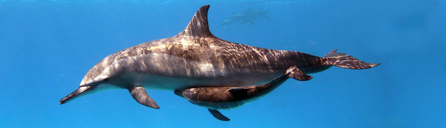
- Marine Life – Encounters include glass fish, anthias fish, puffer fish, clown fish, octopus, morays, stingrays, eagle rays, fantail stingray, scorpion fish, stone fish, lion fish, snake eel, and dolphins.

SAKHWAT ABU GALAWA
BEGINNER | DRIFT DIVING | MAX DEPTH: 22 METER
Location
GPS – POSITION 27° 19. 39′ N 33° 47 . 44′ E
Around 50 minutes from El Gouna.
Sea condition - Dive Plan - Marine Life
- Sea Conditions – The sail out here can be bumpy in windy weather since the reef is located in an unprotected open area. The reef offers fairly sheltered moorings.
- Dive Plan – This site is ideally dived as a drift. Jump in a few hundred metres up north along the wall, and put the wall on your right shoulder. You can wander out over the plateau for a few minutes first but the shallow part is better. When you arrive at the small plateau, the reef makes a sharp right turn, eventually 180 going north again.
- Marine Life – Wildlife encounters include glass fish, anthias fish, puffer fish, clown fish, octopus, morays, stingrays, eagle rays, fantail stingray, scorpion fish, stone fish, lion fish, snake eel, and dolphins.

SHAAB EL ERG
ADVANCED | WALL/DROP OFF | MAX DEPTH: 18 METER
Location
GPS – POSITION 27° 23.39′ N 33° 52.05′ E
90 minutes to 2 hours north of Hurghada depending on the weather and where you leave from. It is a vast horseshoe shaped reef with its open side facing south. At the centre of the horseshoe is a shallow lagoon dotted with ergs (hence the name). It is dived in a number of places: on the north point, on the east wall, or on the south west point (illustrated) known as Gota Shaab el Erg. The latter is the most popular. A shallow channel separates a large erg from the main reef. On the south and west sides is a wide sandy plateau and numerous towers and coral blocks.
Sea condition - Dive Plan - Marine Life
- Sea Conditions – It can be rough getting there, but on arrival, you couldn’t find a better anchorage. Current on the Gota is mostly weak.
- Dive Plan – Forget the main reef, there is easily an hour’s good diving on the Gota and its surrounding towers and pinnacles alone. Four very photogenic blocks lie in 16m water to the south (they are cut off from the illustration).
- Marine Life – Most local guides have two things to say about Shaab el Erg – Dolphins and Mantas. Dolphins can be seen frequently all year round in the lagoon, manta hang out on the north point and are seasonal (February, March are the best months). On the plateau surrounding the Gota are scorpionfish, leopard groupers, snowflake morays, blue-spotted rays and painted triggerfish. Underneath the table corals look for whitetips. In the sand you can find coneshells, spire shells and flatfish. On the shallow reef reside unicorns, emperor fish, bream and snapper.

Blind Reef
Will be added to our program at a later date
ADVANCED | DROP OFF – DRIFT DIVING | MAX DEPTH: 30+ METER
Location
GPS – POSITION 27° 33.02′ N 33° 53.57′ E
Around 110 minutes from El Gouna. Shabrur siyoul, or blind reef as it is commonly called, is a reef where the coral is just barely underwater. This is a further dive as it is almost a 2 hour ride from El Gouna to the north. The south plateau is more popular to dive with beautiful soft coral at 20m. The north wall is great for drift diving.
Sea condition - Dive Plan - Marine Life
- Sea Conditions – Very exposed to the weather with little protection. beware of strong currents here. Some experience required.
- Dive Plan – As expected, this site should be dived as a drift. Jump in on the north side and drift along the wall. It’s a good idea is to make a current check first and find the split point. Both the east and the west side offer an excellent dive so take the easy way and follow the current.
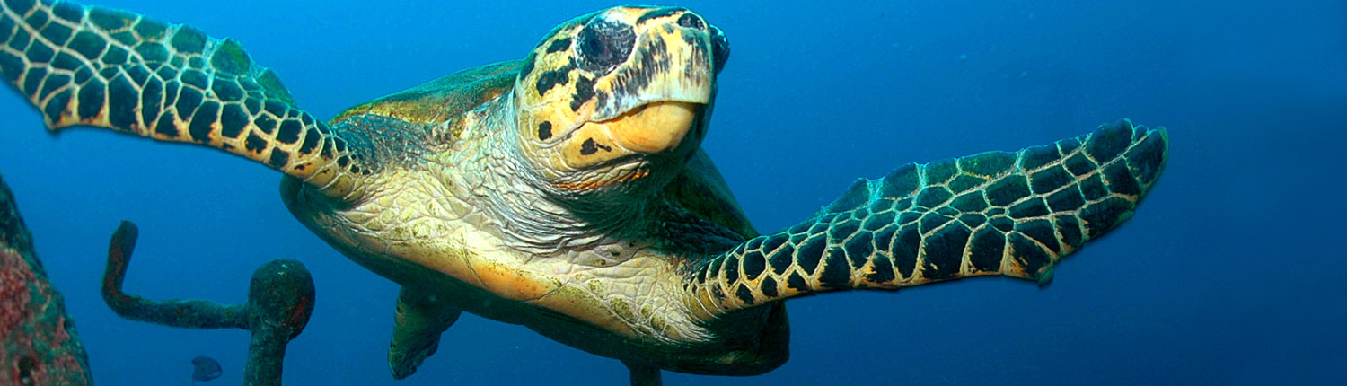
- Marine Life – small caves and cavities in the reef are populated by glassfish seeking shelter from predators like jackfish, mackerel and tuna. Pufferfish and porcupinefish are common here, and the chance to encounter a free swimming moray or a turtle is also good

Carnatic
Will be added to our program at a later date
ADVANCED |WRECK DIVE | MAX DEPTH: 27 METER
Location
GPS – POSITION 27° 34.53′ N 33.32′ E
Around 120 mins from ElGouna on the northwest side of Shaab Abu Nuhas. Between The Chrisola K and The Ghiannis D lies the Carnatic. She hit the reef in 1869, broke up and sank the following day as the weather worsened. She was a passenger and mail ship for the P&O company and the story goes that eight thousand of her forty thousand sterling bullion remains unrecovered. Her sister ship, The Pera Alma, met a similar fate and lies on the reef of Mushajirah in Yemen.
Sea condition - Dive Plan - Marine Life
- Sea Conditions – The Carnatic lies very close to the reef in an exposed position. She must be dived by zodiac in all but exceptional conditions due to large swells breaking on the reef behind. It is best to buoy the bow section at around 15m, here the divers may make their descent and ascent. Take care on this wreck, weather conditions can change rapidly and unexpectedly.
- Dive Plan – The Carnatic lies at a forty-five degree angle to the reef on a gravel seabed, between 20m and 30m. She has broken up midship, leaving her bow and stern intact. The decking has fallen away to be replaced by a thick growth of tube sponges, alcyonarians and occasional table corals, making her very photogenic. She is also laid open to light from above and is easily penetrated.
- Marine Life – As with most wrecks , glassfish have taken over the Carnatic. alongside are their predators – lion fish , jackfish and groupers .Nudibranchs like the bighorn nembrotha and pyjama slug are often seen , as well as twin chromodoris and cute risbecia.

El Gelwa
Will be added to our program at a later date
BEGINNER – ADVANCED| WALL/DROP OFF | MAX DEPTH: 18 METER
Location
GPS – POSITION 27° 33.26′ N 33° 52.20′ E
Around 110 minutes from El Gouna. El Gelwa is on the westside of the Siyoul Kebir Island and has a lot of nice coral blocks covered in soft corals. Sometimes there can be a strong current here.
Sea condition - Dive Plan - Marine Life
- Sea Conditions – The reef is protected from the waves but not from the wind. Be careful here as the current can catch you out.
- Dive Plan – You can either dive this site from the mooring, or as a drift dive: both options are equally beautiful. From the mooring, you begin your dive heading west into the coral garden. When you find the first pinnacle you adjust north, and the next two pinnacles lie in a straight line. As you swim further up north over the coral garden, move slightly east and soon you are back at the main reef. At this time, the best thing is too go shallow. The top of the reef is spectacular.
- Marine Life – You will encounter lots of nudibranchs, glass fish, puffer fish, clown fish, and other reef fish. Also, you may see big rays like feather tail rays and eagle rays.

GIANNIS D
Will be added to our program at a later date
ADVANCED | WRECK DIVE | MAX DEPTH: 27 METER
Location
GPS – POSITION 27° 34.42′ N 33° 55.32′ E
Giannis D hit the reef in April 1983 and over the course of two weeks slowly split in two and sank. She is undoubtedly one of the best wreck dives in The Red Sea. To find The Giannis D, leave the lagoon via the channel to the west. Proceed slowly along the northern reef at a distance of about 50m. It can be seen from the surface after about 200m.
Sea condition - Dive Plan - Marine Life
- Sea Conditions – Of the 4 wrecks, this is the most accessible in rough seas. It takes extremely foul weather to make it out of bounds to divers equipped with a zodiac. Current is minimal.
- Dive Plan – The best part of the wreck is the stern section. It lies on the seabed at 28m, upright but slightly skewed to one side. She is an ideal wreck for penetration, with a number of entry and exit points. Because she is skewed, the interior has impossible angles and perspectives. You find yourself swimming up a stairwell which your mind tells you is heading down. The effect is very disorientating and the conflict between balance and vision can even lead to sea sickness. The engine room is at the centre of this zone. It is large and spacious, but dark. Ladders and stairways run in all directions, from the funnel at the top to the deck plates below and even beneath them. Take a torch. There is a large air pocket in the engine room. This should be avoided unless you want to be covered in the layer of oil that floats on the water’s surface.
- Outside the stern section the masts, railings, wires and cables are festooned with soft corals. Some dramatic photographs can be taken of the superstructure silhouetted against the light. The bow section is also picturesque, but is a long swim away. Your time and air might be better used exploring the shallow mast and rigging of the stern, where you can also do your safety stops.
- Marine Life – Large potato cod often hang out to the north and free swimming morays are common. Rabbitfish and parrottish graze the algal moss that covers the metalwork, as do a variety of nudibranchs.

SIYUL AL KABEIR
Will be added to our program at a later date
ADVANCED |WALL/DROP OFF | MAX DEPTH: 31 METER
Location
GPS – POSITION 27° 33.25′ N 33° 52.27′ E
Siyoul Kebir, also known as Ras Siyoul, is on the Siyoul Island, about 1 hour and 45 minutes to the north of Elgouna. This dive site its suitable for all levels with nice coral reefs and 2 nice big blocks of corals under the mooring line full of anthias fish. Sometimes there is a current which can be used for drift dives. But it can be vicious on the north side.
Sea condition - Dive Plan - Marine Life
- Sea Conditions – there are protect moorings behind the reef but the trip out can be rough over open seas . the current can be vicious on the north side .
- Dive Plan –You have two options here. One alternative is the obvious drift from the north side along the wall. You turn around the east corner over the plateau. Gradually move shallower, and finish the dive with a safety stop around the pinnacles to the south.
- Marine Life – You will see clown fish, moray eels, lion fish, napoleon wrasse, octopus, stone fish, scorpionfish, fire fish, flute fish, trigger fish, puffers fish, and sometimes zebra sharks laying in the sand.

SIYUL AL SAGHIR
Will be added to our program at a later date
BEGINNER | WALL/DROP OFF | MAX DEPTH: 22 METER
Location
GPS – POSITION 27° 32.34′ N 33° 51.55′ E
Around 110 minutes from El Gouna.
Sea condition - Dive Plan - Marine Life
- Sea Conditions – Like Siyul Al Kabeir, the moorings are protected behind the reef but the trip out can be rough over open seas. The current can be strong on the north side.
- Dive Plan – It is a nice and easy dive, suitable for all level of divers, starting from 10-12 m deep to 18-22 m deep. There is a possibility for a drift dive, jumping in on the north side, you swim with the reef to your right and will most likely have the current with you on your way back. The shelf is interesting enough for a closer look but it’s the main reef that is the best part on this part of the dive.
- Marine Life – you can expect to encounter schools of snappers , surgeonfish , and goatfish along the wall . the reef also the habitat for napoleon wrasse , grouper and moray eel. Turtles come by now and then . giant pufferfish and blue spotted rays lie in the sand . you are also likely to see scorpionfish and stonefish .