SOUTH DIVE SITES
MANGROVE BAY
DESCRIPTION
MANGROVE BAY
- Location –
- Sea Conditions – One of the oldest known dive sites in this area, Mangrove Bay has certainly kept its beauty over the years.
- Dive Plan – This is a great dive site for all diver levels with very healthy corals and easy access to the water from shore.
- Marine Life – The formation of the bay keeps this site protected from the waves and rough seas, making it a great place to see common Red Sea marine life like fish, turtles, dolphins, and rays.
DIVE TYPE
WALL/DROP OFF
CLEANING STATION
LEVEL
BEGINNER
MAX. DEPTHT
16 METER
LOCATION
GOOGLE MAP LOCATION
MARSA UMM GERIFAT SOUTH
DESCRIPTION
MARSA UMM GERIFAT SOUTH
- Location –
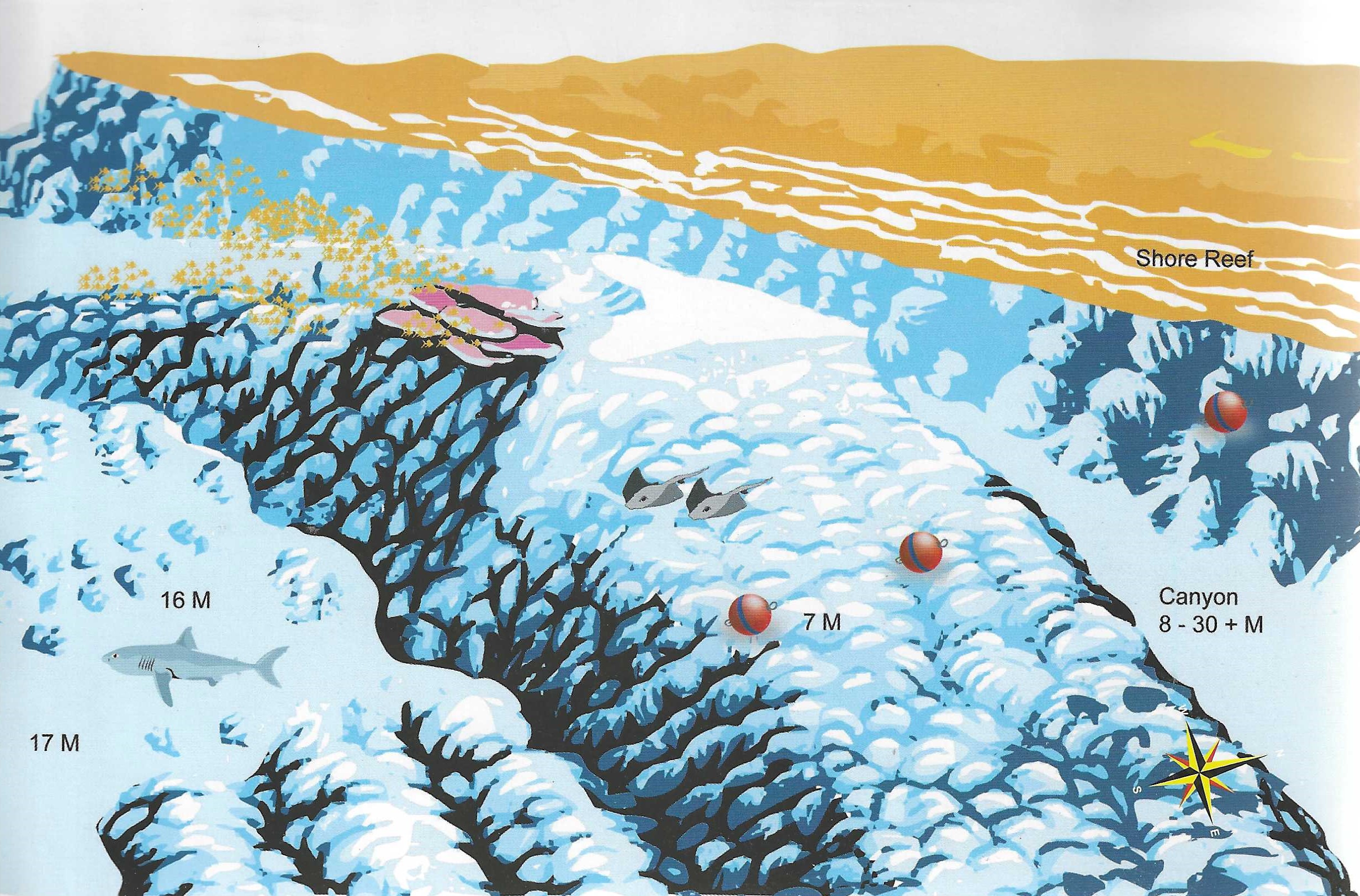
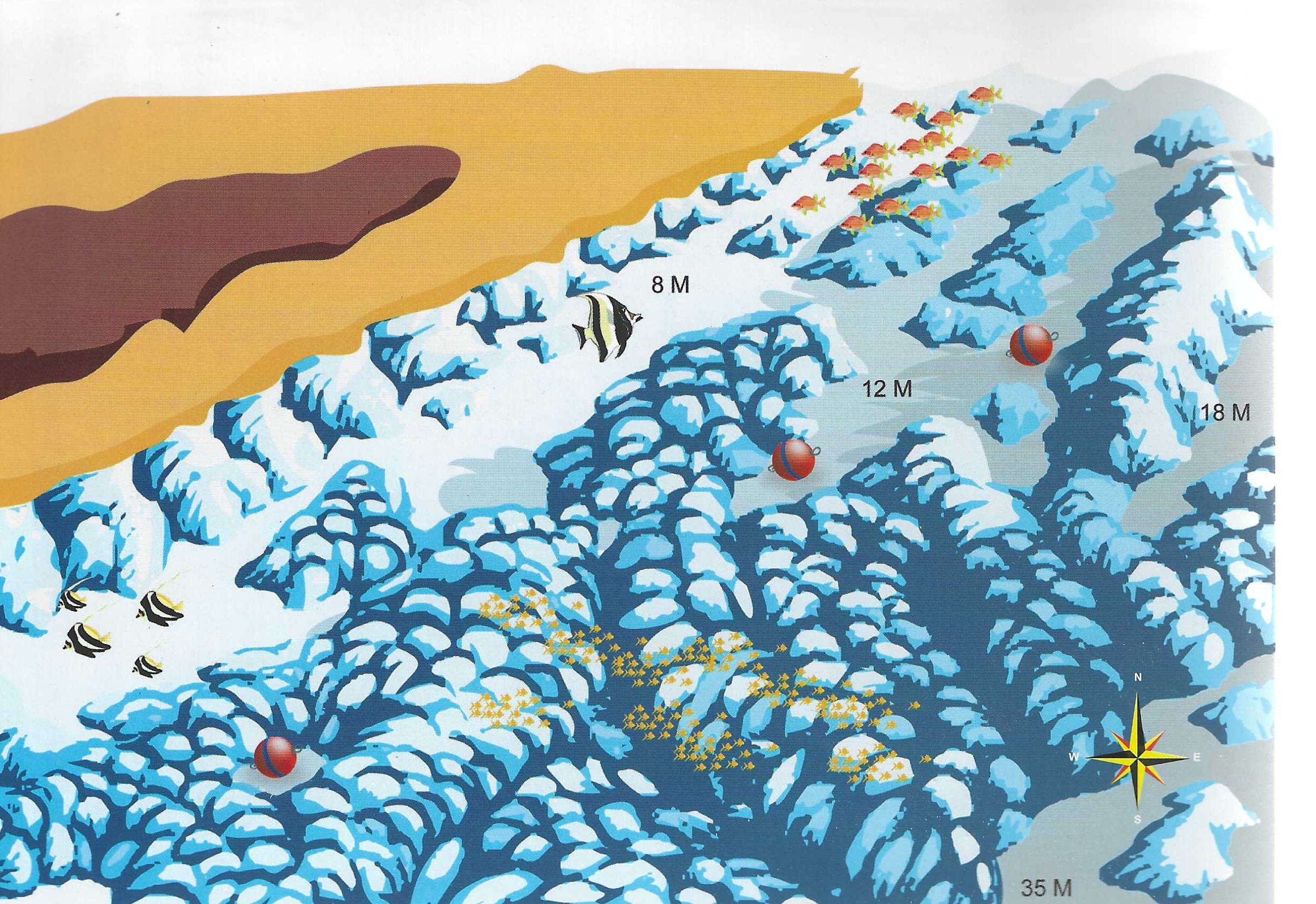
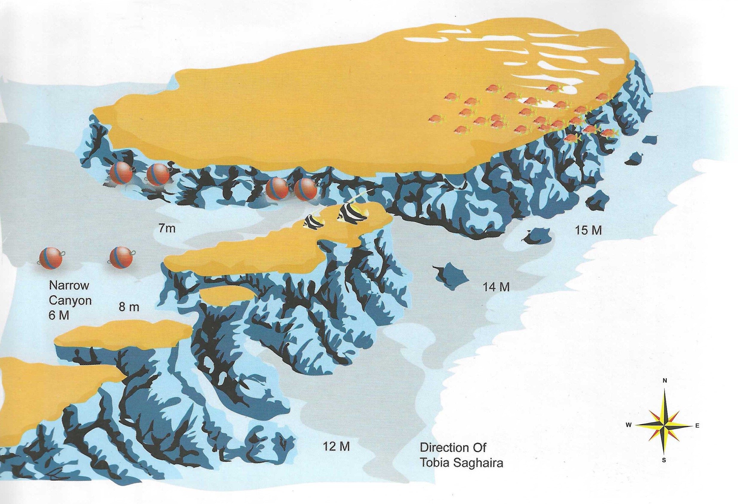
- Sea Conditions – Snorkelers and divers can enter the park via the jetty/zodiac, speedboat, or beach. The entrance is very easy because you enter the water from a staircase. This site is a slowly sloping reef with many plateaus and up to 40m depth. There is a beautiful canyon at 6 – 18m. Training platforms at 2,3,5 and 9m.
- Dive Plan –
- Marine Life – Turtles, whitetip reef shark, Napoleon, lionfish, moray eels, ghost flute fish, whale shark, manta ray, clownfish, stonefish, barracuda, titanium triggerfish, scorpionfish, dolphins.
DIVE TYPE
WALL/DROP OFF
DRIFT DIVING
LEVEL
BEGINNER
ADVANCED
MAX. DEPTHT
18 METER
SHAAB MARSA ALAM
DESCRIPTION
BANANA REEF
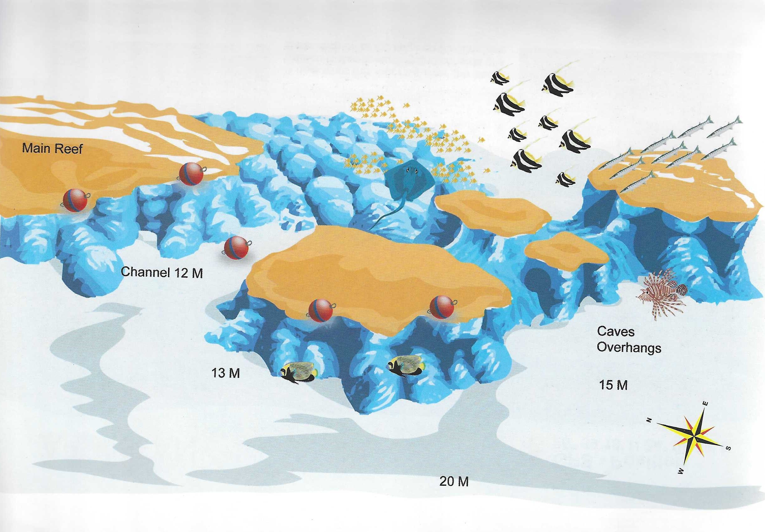
- Location – Just off the end of Ben el Gebel in the middle of the Giftun Strait sits Banana Reef. It is also known as Gota Ben el Gebel, Gota Torfa el Shait or more poetically Shaab Farina (meaning “dragonfly reef,” look at its shape to see why). It’s a Y-shaped reef lying in shallow water (15m))
- Sea Condition – It’s pretty well sheltered to the south of the reef where the moorings are. Current can often be very strong. Being in shallow, sandy water the visibility drops dramatically in bad weather.
- Dive Plan – you can moor up and dive on either side of the reef. The northeast point has some shallow caves. The northwest point, on the other hand, has a particularly stunning erg. Don’t waste time on the lee (south) side of the reef. It is naturally dead. Head towards the outer reef. At the corner is a fan shaped boulder that is home to a school of bannerfish. Here you should turn away from the main reef and head west 20m away is a 4m high pinnacle, carpeted in purple soft corals, another 20m beyond that is the erg. It is overhanging on the south side with a “nest” of coral fragments beneath. The north side is sloping and also carpeted in pink, purple and lilac soft corals. Beyond it is a gorgonian clad boulder. To the north the reef slopes to 20m+.
- Marine Life – Mainly bannerfish but also unicorns, emperor angelfish and puffers.
DIVE TYPE
DRIFT DIVING
NIGHT DIVE
MACRO SPOT
CLEANING STATION
SNORKELING
PINNACLE, NEEDLE, SEAMOUNT
LEVEL
BEGINNER
ADVANCED
MAX. DEPTHT
18 METER
ELPHINSTONE REEF
DESCRIPTION
ELPHINSTONE REEF
- Location – This is one of the most famous dive site in Egypt.
- Sea Conditions – The Elphinstone Reef is full of healthy corals, magnificent clear blue water, and rich marine life. It is also a great destination to see your first shark.
- Dive Plan –
- Marine Life – The dive site location, environment, and reef formation makes this site one of the most important locations for sharks such as the oceanic whitetip and hammerhead shark.
DIVE TYPE
WALL/DROP OFF
LEVEL
ADVANCED
EXPERT
MAX. DEPTHT
28 METER
ELPHINSTONE SOUTH
DESCRIPTION
ELPHINSTONE SOUTH
- Location–
- Sea Conditions – Elphinstone South is an amazing off-shore reef dive and preferred by many as an afternoon dive due to the fantastic lighting.
- Dive Plan – The dive slopes down from 18m deep to the deepest top of the plateau at 40m.
- Marine Life – This spot is famous for the Oceanic whitetip sharks which are very common during Oct, Nov, and December. You will also see very healthy hard and soft corals, lots of fish and have a great chance to see manta rays and baracuda.
DIVE TYPE
WALL/DROP OFF
LEVEL
ADVANCED
EXPERT
MAX. DEPTHT
30 METER
ABU DABAB II
DESCRIPTION
ABU DABAB II
- Location – Reef and coral garden in front of Abu Dabbab Bay.
- Sea Conditions – Beautiful cave with bright light inside. Small and old wreck beautifully covered with soft corals. Approachable by zodiac.
- Dive Plan –
- Marine Life – Various coral gardens and canyons, many parrotfish, and surgeonfish. Small eagle rays and Napoleon wrasse as well.
DIVE TYPE
WALL/DROP OFF
LEVEL
BEGINNER
MAX. DEPTHT
16 METER
FANOUS WEST
DESCRIPTION
FANOUS WEST
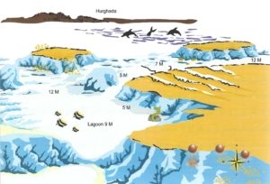
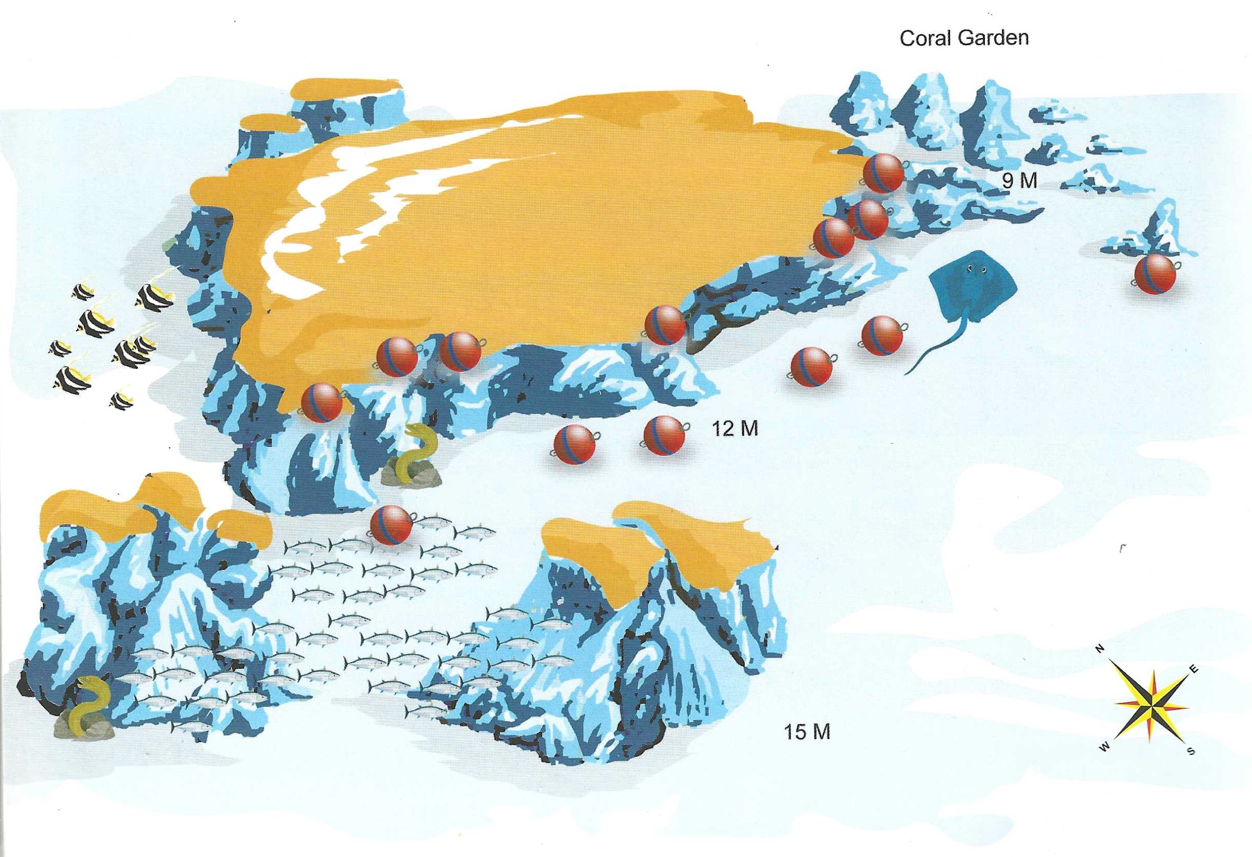
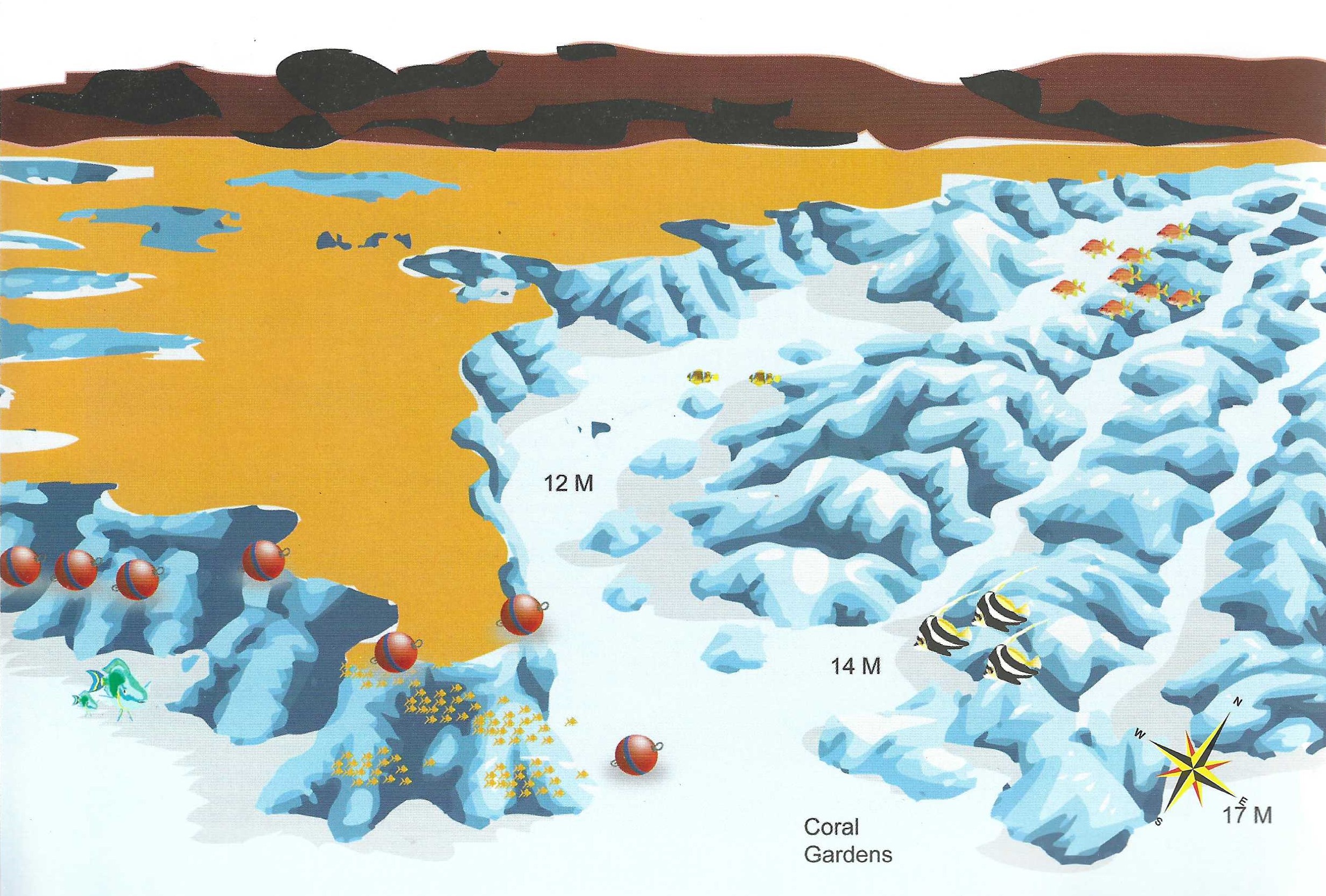
- Location – On the western end of the Fanous reef, a narrow “fossma” or channel breaks through the reef wall to a lagoon outside at 9m and an area of coral garden at 12-14m. There are two main ergs and various outlying coral pinnacles.
- Sea Conditions – The boat can moor on the inside of the fossma in any weather. Here it can remain in the sanctuary of the Fanous lagoon while divers venture outside. The current will only run on the outer wall, direction northeast to southwest. It can run strong, in which case the best approach is a drift dive, dropping in north of the ergs and returning with the current to the boat at the moorings.
- Dive Plan – If you’re not taking the drift option (above) then head out through the fossma (4m). Don’t waste time in the lagoon (9m). It is naturally dead. At the corner you make a choice, either keep following the main reef northeast, or head straight out. There is a prominent coral lump about 20m ahead which lines you up with the main erg (50m away). It is nicest on the north end. To the south are two other large pinnacles.
- Marine Life – The usual reef fish and plenty of them – picassos, painted triggers, morays, snowflake morays, octopus, squid, butterflyfish and turtles. Dolphins regularly pass through in the afternoon, usually heading north to south.
DIVE TYPE
WALL/DROP OFF
LEVEL
BEGINNER
MAX. DEPTHT
METER
GAMUL AL KABEIR
DESCRIPTION
GAMUL AL KABEIR
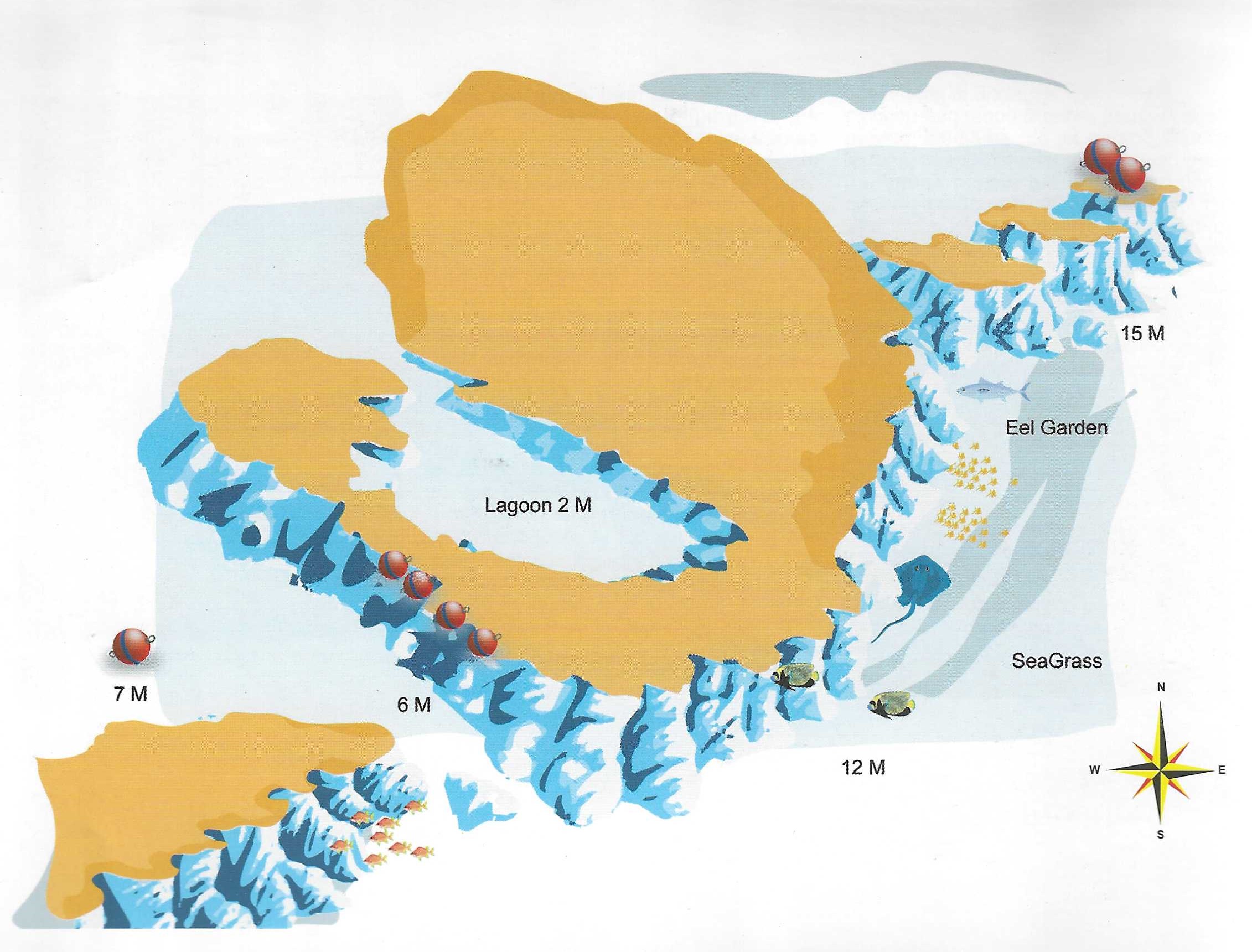
- Location – Just north of Shadwan Island and about 20 minutes from Safaga is a large round reef known as Gamul al Kebeir. At its centre is a perfect, circular lagoon. To the south is a long nondescript reef and to the northeast are three small and colourful ergs. All around are sea grass beds.
- Sea Conditions – It is accessible in any weather and the moorings are very sheltered. Current comes from the northeast and can occasionally run quite strong.
- Dive Plan – Either leave the boat at the moorings and head out through the “fossma” in the direction of the three ergs (it takes 20-30 minutes depending on current), or enter the water in the region of the three ergs. Your boat can then head down to the moorings where you can reach it later.
- Marine Life -This reef is known for a mean-looking school (15-20) of big barracuda 1.5m+. They are a mixture of chevron and pickhandle barracuda and operate in the region of the three ergs or over the seagrass beds to the north of the main reef. Eagle rays are also commonly seen here as are whitetips and also, though more rarely, sea cows. Around the ergs are unicornfish, snappers, bigeye emperors, bream and scrolled filefish. In the sand live a colony of garden eels and if you look closely, pegasus or sea moths may also be found.
DIVE TYPE
WALL/DROP OFF
LEVEL
BEGINNER
MAX. DEPTHT
METER
GAMUL AL SAGHIR
DESCRIPTION
GAMUL AL SAGHIR
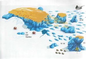
- Location – Less than 15 minutes outside Safaga lies Gamul al Saghir. It is the second in a chain of reefs stretching northwards from Safaga Island. It is round in shape with four outlying ergs to the southeast. Only two can be seen from the Surface.
- Sea Conditions – You can reach Gamul al Saghir in any weather. In fact, when it’s too rough to get to the outer reefs, it is your best chance of aquality dive. The current comes from the north, splits and runs down either side of the reef.
- Dive Plan – Head straight to the ergs on the southeast side of the reef, taking in the eel garden en route. The large erg nearest the main reef reaches the surface from 13m, outside it, in 16m of water, is a hollow pillar 6-7m high with agorgonian inside. About 60m south of here is a very picturesque horseshoe shaped erg and 70m south of that is the best erg of all. It reaches the surface, standing in 18m water and is overhung on the south side with glassfish, hatchetfish, cardinalfish and silversides in abundance, along with their normal predators. Having completed the ergs, check your air. If you have over 100 bar, you may circle the main reef. If you have less, then work your way slowly back to the boat.
- Marine Life – On the ergs, schools of bream, batfish, bigeye emperors, sweetlips, bannerfish, fusiliers, red snapper and black snapper. Hunting the glassfish – redmouth grouper and lionfish. On the main reef , squirrelfish, soldierfish, glasseyes and cardinalfish in the many crevices. Sweetlips schooling alongside snowflake groupers and lunartail groupers and bluespotted rays everywhere.
- Rarities – There is a green anemone on the hollow coral pillar whilst on the main reef a frogfish is resident (position undisclosed) and in ’97 a sea cow made this her home for a while.
DIVE TYPE
WALL/DROP OFF
LEVEL
BEGINNER
MAX. DEPTHT
METER
GIANNIS D
DESCRIPTION
GIANNIS D
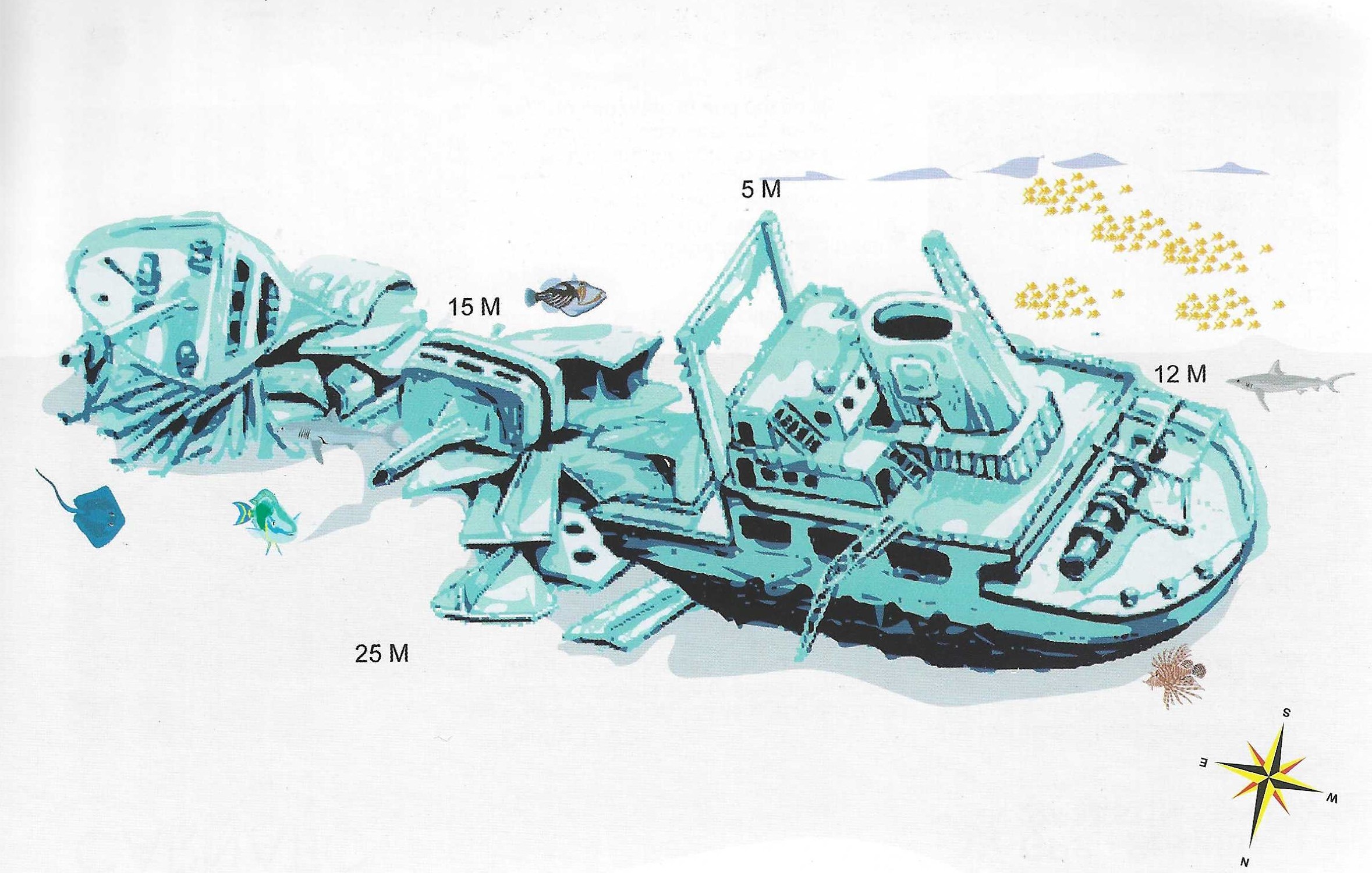
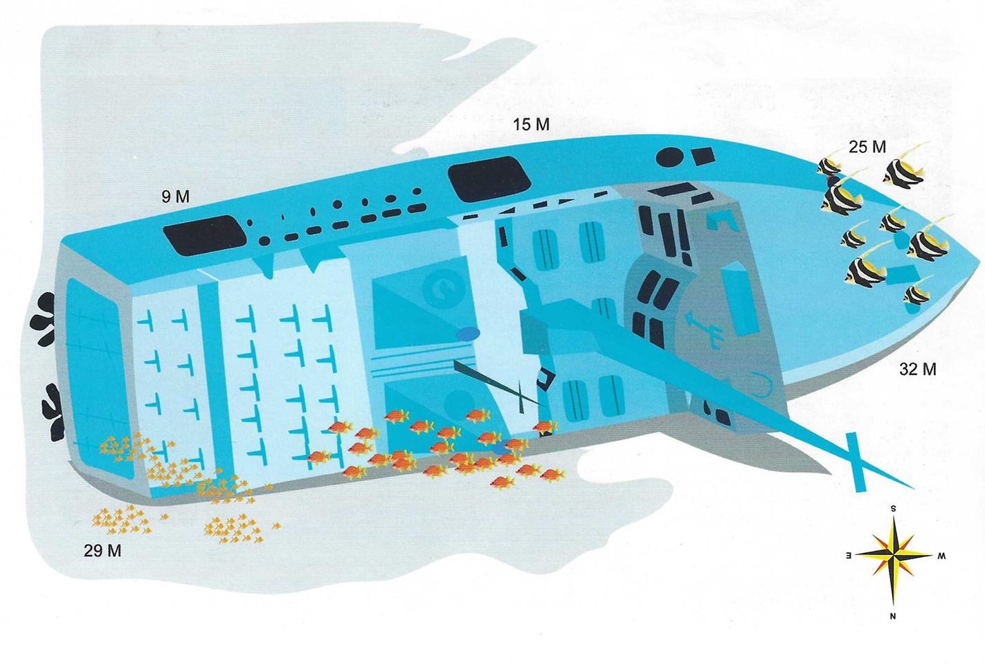
- Location – Giannis D hit the reef in April 1983 and over the course of two weeks slowly split in two and sank. She is undoubtedly one of the best wreck dives in The Red Sea. To find The Giannis D, leave the lagoon via the channel to the west. Proceed slowly along the northern reef at a distance of about 50m. It can be seen from the surface after about 200m.
- Sea Conditions – Of the 4 wrecks, this is the most accessible in rough seas. It takes extremely foul weather to make it out of bounds to divers equipped with a zodiac. Current is minimal.
- Dive Plan – The best part of the wreck is the stern section. It lies on the seabed at 28m, upright but slightly skewed to one side. She is an ideal wreck for penetration, with a number of entry and exit points. Because she is skewed, the interior has impossible angles and perspectives. You find yourself swimming up a stairwell which your mind tells you is heading down. The effect is very disorientating and the conflict between balance and vision can even lead to sea sickness. The engine room is at the centre of this zone. It is large and spacious, but dark. Ladders and stairways run in all directions, from the funnel at the top to the deck plates below and even beneath them. Take a torch. There is a large air pocket in the engine room. This should be avoided unless you want to be covered in the layer of oil that floats on the water’s surface.
- Outside the stern section the masts, railings, wires and cables are festooned with soft corals. Some dramatic photographs can be taken of the superstructure silhouetted against the light. The bow section is also picturesque, but is a long swim away. Your time and air might be better used exploring the shallow mast and rigging of the stern, where you can also do your safety stops.
- Marine Life – Large potato cod often hang out to the north and free swimming morays are common. Rabbitfish and parrottish graze the algal moss that covers the metalwork, as do a variety of nudibranchs.
DIVE TYPE
WALL/DROP OFF
LEVEL
BEGINNER
MAX. DEPTHT
METER
GOTA ABU RAMADA
DESCRIPTION
GOTA ABU RAMADA
- Location – This reef, also known as the aquarium, lies between 50 and 90 minutes from Hurghada depending where you depart from. It is an elliptical reef surrounded by a sandy seabed at 12-15m. To the west are two large ergs and to the east are three pinnacles and a coral garden.
- Sea Conditions – The sea is usually calm. At its worst a little swell can be felt curling round the east and west corners of the reef. The current splits on the northern reef and, like the sea, can only really be felt at either end of the reef.
- Dive Plan – a) The east side is ideal for photographers. The area is teeming with yellowfish amongst the gullies and grottoes that characterise this end of the reef. About 15-20m off to the southeast are three small pinnacles with abundant fish life. b) Two larger ergs stand 20m off the west end of the reef. They are typified by soft corals, gorgonians and stacks of fish.
- Marine Life – All over the reef, but especially at the west end, there are yellowfish, bannerfish, bluecheek butterflies, masked butterflies, yellow snapper, goatfish and sweetlips. Big morays, jacks, turtles, crocodilefish and more infrequently, eagle rays and leopard sharks visit the reef. Titan triggerfish are guarding their nests in September. Watch out.
DIVE TYPE
WALL/DROP OFF
LEVEL
BEGINNER
MAX. DEPTHT
METER
HAL HAL
DESCRIPTION
HAL HAL
- Location – Hal-Hal is a fisherman’s expression meaning restless sea and it’s true, the sea is almost constantly choppy here. Two ergs push up from the edge of a plateau to about 3m short of the surface and offer no protection. They lie about 400m southeast of Middle Reef. On the inside (west), the plateau has 16m depth, whilst on the outside it drops to a wide ledge at 22-24m. This ledge has a drop-off about 80m cast which is vertical, if not overhanging and starts at 30m. Hal-Hal is also known as Shaah Kweiss (meaning “Nice Reef”) but then so is any reef in The Red Sea that your skipper has forgotten the name of.
- Sea Conditions – You’ll need exceptional conditions to reach Hal-Hal and even then, nine times out of ten, the current will be too strong to even get in the water.
- Dive Plan – If you’re lucky enough to make a dive here, you’ll find the most vibrant, colourful, lively reef you’ve ever seen. The fish don’t sleep here, they constantly’ twist and turn in a game of eat or be eaten. The site is so compact you can circle it 2-3 times at ascending depths, but don’t go with a plan – the current will make your mind up for you. Visit the drop-off to look for pelagics, but only if you’re very good on air and have a strong sense of direction.
- Marine Life – The reef is a blaze of soft corals and gorgonians, with a sizeable table or two. As far as fish life goes, you’ll see the normal stuff but tons of it. Leopard groupers, turtles. goatfish, scrolled filelish, unicorns, longnose unicorns and whitetip sharks to name a few. On the top of the ergs, red-mouth groupers line up to snatch at the clouds of anthias instead of their normal prey, glassfish. A school of bannerfish hugs close to the reef for protection. On the drop-off, you’ll see snapper schools, surgeonfish schools, schools of small tuna, large solitary tuna and, at certain times of year, a school of Spanish mackerel that stretches as far as the eye can see.
DIVE TYPE
WALL/DROP OFF
LEVEL
BEGINNER
MAX. DEPTHT
METER
HAMDA
DESCRIPTION
HAMDA
- Location – Hamda is situated on the northeast side of Giftun Kebir, beneath a series of prominent cliffs and opposite a white, shingle beach. It goes by several names: Hamda, Umm Dom, Hamata or Stone Beach for starters. Beneath the water is a small plateau of hard coral sloping easily from 15 to 35m. On the outside, the plateau drops off in a series of smooth, rounded rocky ledges. At both ends the plateau gives way to a steep wall tumbling to 50m+.
- Sea Conditions – If the wind is coming from the northwest the place is well sheltered, but from the north and north-east it is very exposed. Current is negligible.
- Dive Plan – It’s worth going to have a look at the drop-off, if only to remind yourself how much more life and colour there is shallow. It is stark, bare rock and somewhat lunar looking. Beneath the boat look out for a large green salad coral. As you head north across the plateau you will notice two large sand patches at 15 and 18m. Not far beyond here the wall starts. On your way back stay really shallow (3-4m), this is probably the best part of the dive.
- Marine Life – In open water above the plateau there are large schools of blue fusiliers and redfang triggerfish and, solitary tuna, snapper and unicorns. On the plateau you’ll find morays, scorpionfish, barracuda, maybe sharks or turtles and there are many cleaning stations where fish hover, mouths open, under the attention of cleaner wrasse. This has also been the scene of a couple of whaleshark sightings.
DIVE TYPE
WALL/DROP OFF
LEVEL
BEGINNER
MAX. DEPTHT
METER
MIDDLE REEF
DESCRIPTION
MIDDLE REEF
- Location – 90 minutes to two hours outside Safaga, Middle Reef is a very large circular reef with dozens of small, shallow ergs on its southeast corner. On the north and west sides are coral gardens that drop off at approximately 30m. To the south is a lone erg standing in 20m water. On the east side a wide plateau stretches out as far as Hal-Hal nearly 500m away. It is covered by one of the most scenic hard-coral gardens in the Red Sea. It too has a drop-off, but a long way to the northeast of the main reef.
- Sea Conditions – On the way out you are crossing the weaves so the boat will roll a lot. However, once out there, the mooring site is extremely sheltered. A current runs almost constantly from the north and varies from mild to howling.
- Dive Plan – You can drift dive north, west or east drop-offs (your best chance of seeing big fish) provided the sea is calm. Most people dive from the moorings, taking in the brain coral garden and east plateau. It is a labyrinth of sand patches and coral ridges. Be careful here. People have been lost by surfacing in open water above the plateau and being swept away, unseen, by the current. Carry a delayed SMB or better still a compass.
- Marine Life – Middle Reef is dived more for its picturesque corals than for its fish life. However, all kinds of parrotfish and triggerfish can be seen in abundance. On the drop-offs, tuna, Spanish mackerel, giant trevallies and schooling surgeonfish are usually seen, plus occasionally grey reefs, white tips and, in late summer, hammerheads. Near the moorings, you can find turtles, morays, a school of 300-400 Juvenile barracuda and a school of black snapper.
DIVE TYPE
DRIFT DIVING
NIGHT DIVE
CAVERN/CAVE
LEVEL
BEGINNER
ADVANCED
EXPERT
MAX. DEPTHT
20 METER
NORTH ABU RAMADA
DESCRIPTION
NORTH ABU RAMADA
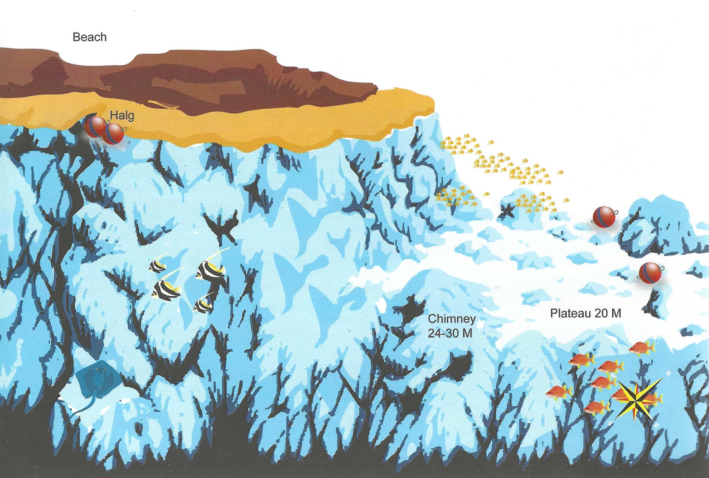
- Location – North Abu Ramada is between 60 and 90 minutes out of Hurghada. Where the island stops at the north end a long platcau continues at 20-50m, tailing gently off. On the east side it drops off sheer, blending with avertical wall to the south. Like Umm Gamaar, there is a “Halg” or neck on the east side of the island where your boat can often wait.
- Sea Conditions – Usually too rough to moor up (except at the Halg), so the dive is done as a drift dive. Occasionally, during a south wind, boats will tie up on the plateau. A bullish current stampedes across the plateau much of the time. It makes for some thrilling diving but take care.
- Dive Plan – Unless you are lucky enough to moor here, then drift dive it. Jump in directly north of the reef and head immediately east to the drop-off.On your way, you should pass a large coral block from 15 to 20m. The drop-off is at 25m. Just past here is an inconspicuous hump with its top at around 20m. It is packed with small holes which suggest it is hollow. It is. Follow it down to 31m where you can enter aspacious cave that chimneys up towards 25m. It is located just north of where plateau turns into wall. After the caves follow the wall south. It is vertical and the water is very blue. If your skipper Is smart (and the sea allows him) he has moored up in the “halg” (opposite a small beach). You can join him there.
- Marine Life – There is not awhole lot of small fish here but barracuda, tuna and jacks arc common. Even sailfish have been spotted here, and now and then hammerheads.
DIVE TYPE
WALL/DROP OFF
LEVEL
BEGINNER
MAX. DEPTHT
METER
NORTH UMM GAMAAR
DESCRIPTION
NORTH UMM GAMAAR
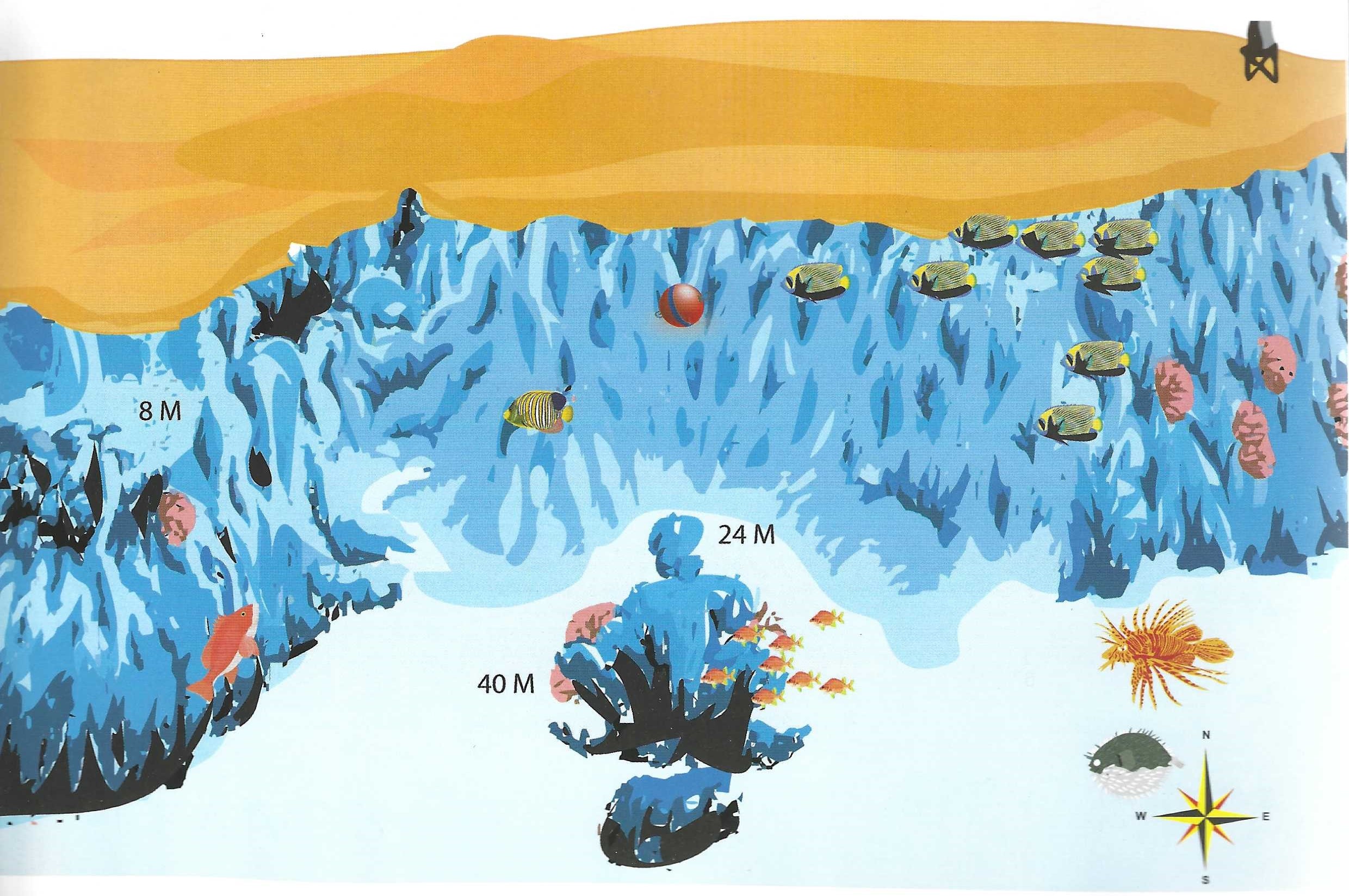
- Location – North Umm Gamar encompasses two sites: the north plateau and Halg Umm Gamaar (“The Neck of Umm Gamaar”) (illustrated), The north plateau is characterised by big table corals, big fish and strong currents. Halg Umm Gamaar is basically a sheltered bay with a wall to the south and a 60◦ coralslope to the north. At its centre, on a sandy bottom are two deep coral blocks.
- Sea Conditions – It has to be fairly calm to even try to moor here because the boat swings very close to the reef. Current picks up as you head northwards.
- Dive Plan – Take in the deep coral blocks first (if you have the necessary experience), then head either way. If you head north, take care not to pass the point at which the current splits. This could result in you getting swept around the corner. If you head south, look out for black coral trees. There is also a cave at 8m just beyond a prominent cleft in the reef top.
- Marine Life – The most common fish here are lunartail and peacock groupers, unicornfish, sohal and orangespine surgeonfish, bannerfish and bluecheek butterflyfish are also in abundance. This reef is special for one thing in particular – Spanish dancers during the day. They are usually between 15 and 20m but they appear as shallow as 4m.
DIVE TYPE
WALL/DROP OFF
LEVEL
BEGINNER
MAX. DEPTHT
METER
PANORAMA
DESCRIPTION
PANORAMA
- Location – Panorama is also known as ‘Abu Alama” meaning ”Father of the Mast.” This is a reference to the concrete pillar which once marked its northern shores but has now been replaced by a hi-tech automated beacon. It lies 60-90 minutes (weather dependent) outside Safaga. It is an elliptical shaped reef on a northwest-southeast axis. On the north end is a dramatic plateau (15-25m) and drop-off. Down the east and west sides runs a narrow sloping ledge at the same depth.
- Sea Conditions – The Journey across can get very rough, especially since your boat will be taking it on the beam and will, therefore, roll a lot. Once you get there, however, the reef gives ample protection for several boats. The current conies (95% of the time) from the north. It can gee very strong, howling across the north plateau (beware of upcurrents and downcurrents) and ripping down either side of the reef. The south plateau is usually calm.
- Dive Plan – A drift dive of the north plateau offers some of the best diving in this book. However, to get there you’ll need very calm weather or alternatively a zodiac. After investigating the plateau, you can head down either wall to your boat, now moored in the lee of the reef (south). This is a long swim if unaided by current. The western wall of the reef is best. The south end of the reef can also be dived from the moorings. The southeast corner boasts many gorgonians.
- Marine Life – North plateau – if it’s big and lives in the sea, you can see it here. Surgeonfish schools, unicornfish schools, barracuda schools, giant trevallies, whitetips (especially on the west side), grey reefs (especially in the afternoon), eagle rays, dolphins, silvertips, and even longimanus, the oceanic whitetip. Everywhere are turtles. South plateau – there is a family of three napoleons, they live alongside morays, crocodilefish, scorpionfish and a turtle with a deformed shell. Also, there is a large colony (50-60) of anemones.
DIVE TYPE
WALL/DROP OFF
LEVEL
ADVANCED
EXPERT
MAX. DEPTHT
26 METER
RAS ABU SOMA
DESCRIPTION
RAS ABU SOMA
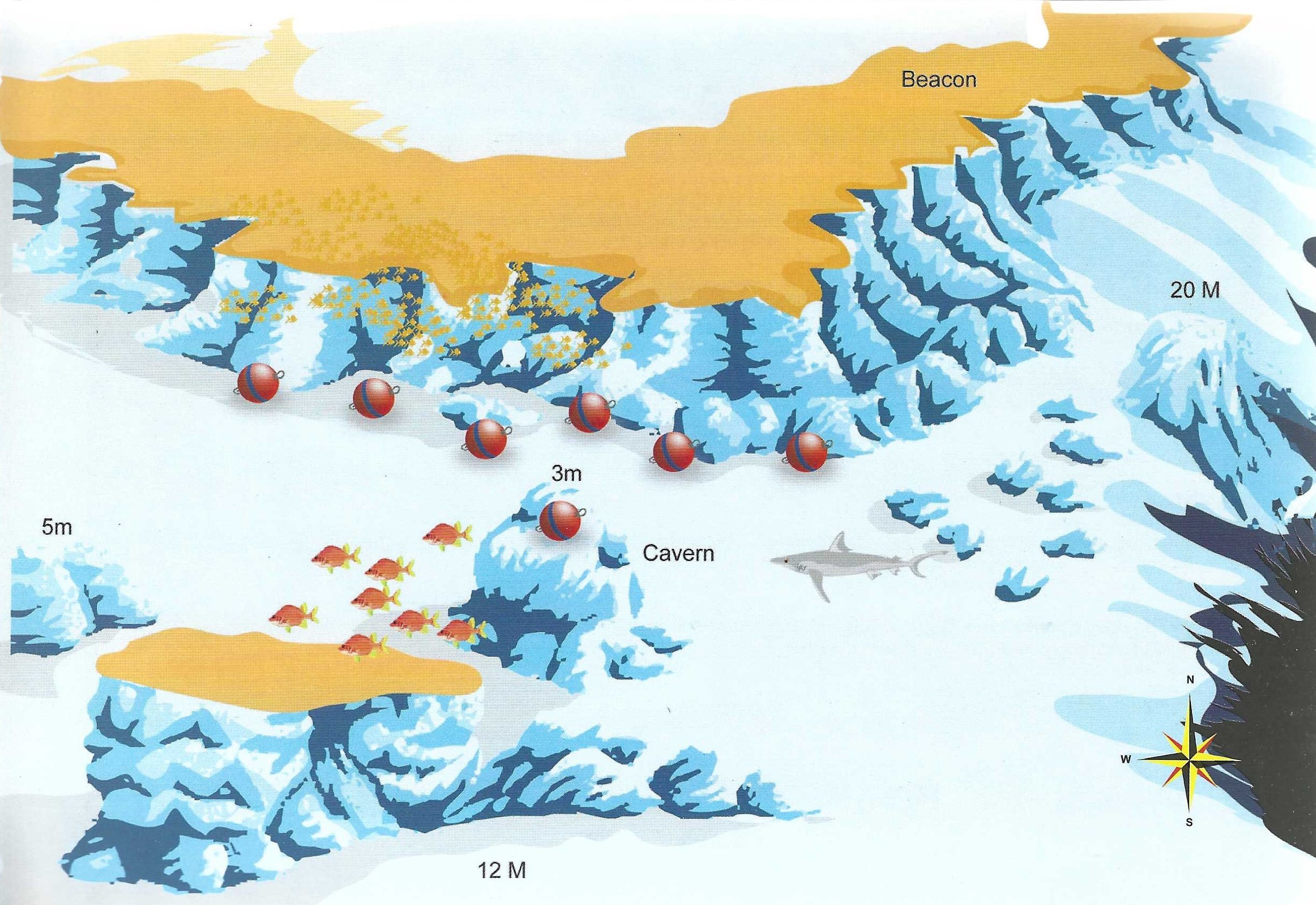
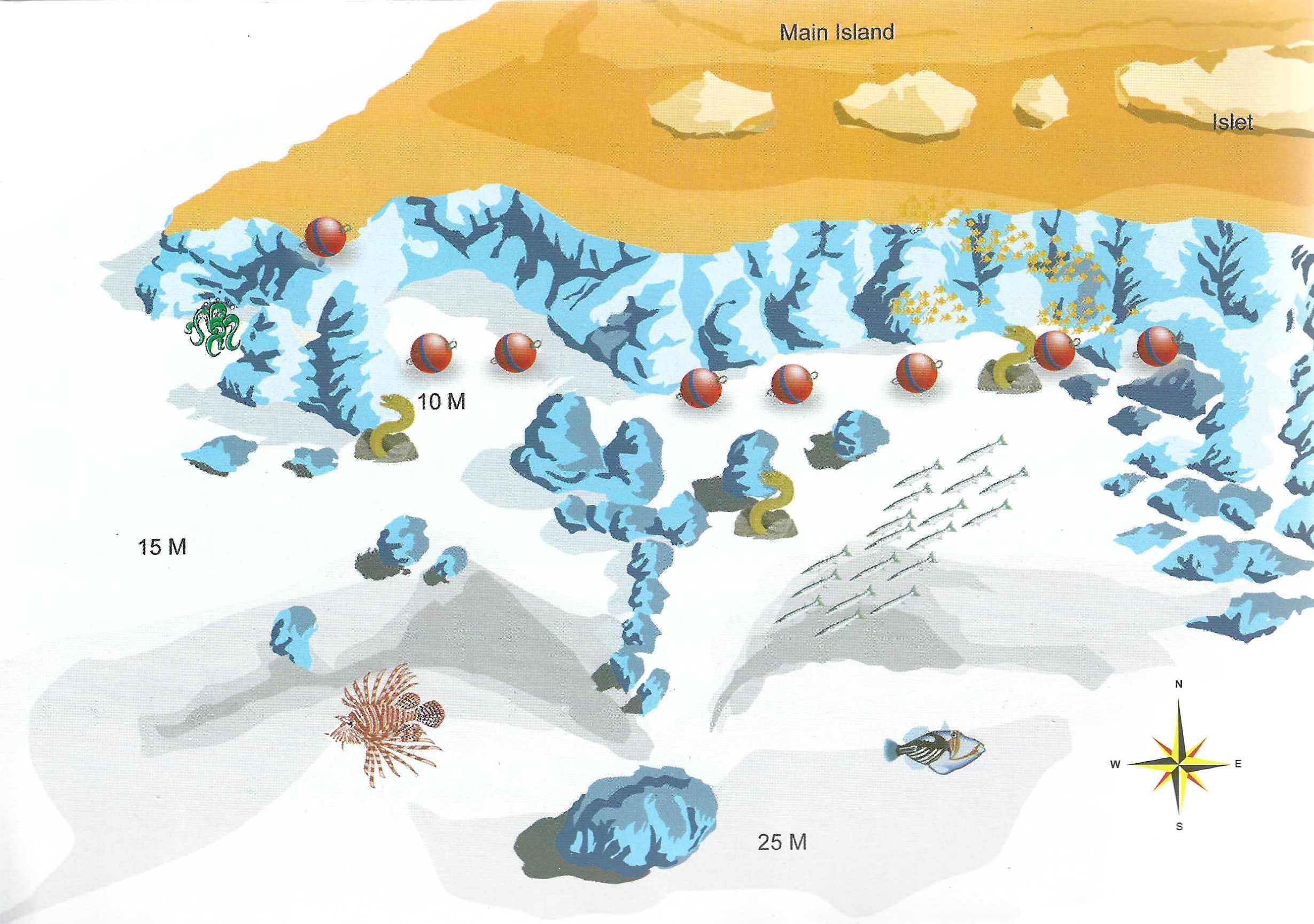
- Location – Ras Abu Soma is the headland that defines the northern limit of the bay of Safaga. There are two dive sites here, Abu Soma Gardens on the inside and the “Ras” itself (illustrated). Both take about 45 minutes to reach by boat. The “Ras” has a steep outer wall that merges with a 25m plateau to the south. The place is virtually a carbon copy of Small Giftun in Hurghada, except the gorgonians are replaced with large table corals.
- Sea Conditions – You are well sheltered here from the weather, but if you make adrift dive you’ll notice the sea pick up dramatically as the boat rounds the corner to drop you off. Current always comes from the north and can get quite strong on the outer wall. The mooring area is current free.
- Dive Plan – The best tactic here is to make a drift dive. Jump in about 400m past the “Ras” but well before the beacon. You’ll find superb visibilhy and a steep wall dropping into the deep blue. As you head south, you’ll notice a ledge start to develop, which leads into the plateau. Before long you’ll notice a faint bay in the reef wall and on the far (south) side of this is a superb cave at 35 m.It is fringed with soft corals, seething with glassfish and is guarded by a large grouper. The plateau above is scattered with some venerable old table corals up to 4m across. Front here head up to the shallow reef and follow it at 4-5m, where it is nicest, until you come to your boat waiting at the moorings.
- Marine Life – This dive is a bit of a gamble. At some times you’ll find the place loaded with big fish. At others, it’ll be completely, empty and devoid of all life. If luck is on your side you’ll see barracuda, jackfish, snapper, tuna and schooling batfish and surgeonfish. The big fish seen here include grey reefs, whitetips. guitar shark, leopard sharks, stingrays, eagle rays. hammerheads and, in March/April, mantas. If you’re unlucky you’ll just see boxfish.
DIVE TYPE
WALL/DROP OFF
LEVEL
BEGINNER
MAX. DEPTHT
METER
RAS DISHA
DESCRIPTION
RAS DISHA
- Location – About 90 minutes south from Hurghada, on the coast, is a wide bay with an island at its centre (Abu Hashish). It is defined to the north by a headland called Ras Disha. There is a plateau of shallow sand and past the beacon, to the north is a drop-off. Three ergs lie to the south. They are probably the nicest diving.
- Sea Conditions – The dive site is well sheltered from waves and current which come predominantly from the north.
- Dive Plan – Forget the main reef. It is largely dead. The best route to take is around the ergs. They rise up from a sandy seabed at l0-12m. The most northerly has a large cavern thick with glassfish.
- Marine Life – On the ergs, the usual hunters of glassfish – jacks, lionfish and redmouth groupers. This place also has the richest sand-dwelling fauna around-crocodilefish, flatfish, stonefish, spiny devilfish, bluespotted rays and sea moths come as standard. On the wall to the north, a grey reef shark is rumoured to hang out, and on the sandy plateau and between the ergs schools of juvenile barracuda.
DIVE TYPE
WALL/DROP OFF
LEVEL
BEGINNER
MAX. DEPTHT
METER
RAS UMM HESIWA
DESCRIPTION
SHAAB ABU NUGAR
- Location – About 60-90 minutes north of Hurghada, Abu Nugar is composed of a long t-shaped reef to the west and a shallow plateau dotted with ergs to the east. Diving takes place on the most south-easterly ergs (Shaab Ins), two large central ergs (Gota Abu Nugar), or on the north side of the tongue pointing west from the main reef. The name Abu Nugar literally means “Father of the Pools” and refers to several clear blue lagoons in the reef top.
- Sea Conditions – It can get a little choppy on the way over but once you get there you’re well sheltered. Current is usually mild.
- Dive Plan – Some parts of this reef system are utterly dull; whilst others offer superb shallow diving with an almost virginal quality to the reefs. If you can, dive the three ergs north of the tongue – they are magical.
- Marine Life – The reef is composed of a wide variety of hard corals: tables, braincorals; etc, The fish life is nothing spectacular but lots of broormtails, parrotfish and unicornfish.
DIVE TYPE
WALL/DROP OFF
LEVEL
BEGINNER
MAX. DEPTHT
METER
SALEM EXPRESS
DESCRIPTION
SALEM EXPRESS
- Location – About 90 minutes from Safaga, south of Shaab Shehr. This wreck sank on December 15th 1991, she hit the Hyndeman reef ripping a massive hole in the hull. The Salem Express is 110m long and 18m wide. She lies at a depth of 12-33m.
- Sea Conditions – This site offers no protection from the weather and the current can be very strong.
- Dive Plan – Resting on her starboard side in 30m of water, the Salem Express is an eerie dive. Begin your dive at the deepest point, the stern, where you find the two intact large screws and the rudders, Swimming along the bottom you pass life boats still at the davits. Next you see the huge funnels with the haunting emblem “S”. Coming up towards the bow, you will find the bow door wide open and the damage from the collision with the reef is daunting. Many dive guides refuse to dive the Salem Express altogether and penetration is most definitely frowned upon. This is a maritime grave and should be treated as such. Dive her with respect.
- Marine Life – Even the marine life seems to have left Salem Express alone. Some groupers, lionfish, crocodilefish and surgeonfish swim around. A small amount of hard coral growth has begun here.
DIVE TYPE
WRECK DIVE
LEVEL
ADVANCED
MAX. DEPTHT
27 METER
SHAAB ABU NUGAR
DESCRIPTION
SHAAB ABU NUGAR
- Location – About 60-90 minutes north of Hurghada, Abu Nugar is composed of a long t-shaped reef to the west and a shallow plateau dotted with ergs to the east. Diving takes place on the most south-easterly ergs (Shaab Ins), two large central ergs (Gota Abu Nugar), or on the north side of the tongue pointing west from the main reef. The name Abu Nugar literally means “Father of the Pools” and refers to several clear blue lagoons in the reef top.
- Sea Conditions – It can get a little choppy on the way over but once you get there you’re well sheltered. Current is usually mild.
- Dive Plan – Some parts of this reef system are utterly dull; whilst others offer superb shallow diving with an almost virginal quality to the reefs. If you can, dive the three ergs north of the tongue – they are magical.
- Marine Life – The reef is composed of a wide variety of hard corals: tables, braincorals; etc, The fish life is nothing spectacular but lots of broormtails, parrotfish and unicornfish.
DIVE TYPE
WALL/DROP OFF
LEVEL
BEGINNER
MAX. DEPTHT
14 METER
SHAAB CLAUDE
DESCRIPTION
SHAAB CLAUDE
- Location – Shaab Claude is the second in a chain of small reefs that extend southward from the east end of Shaab Sheer. It has one prominent erg to the south east, whilst on its southwest corner is a long ridge composed of several ergs that have grown together at the top. Between them are swim-throughs in the 4-6m range. The whole reef stands on a sandy seabed at 15-l8m.
- Sea Conditions -The reef enjoys some protection from the reefs to the north. The current, on the other hand, often rips through here at a rate of knots. Occasionally it can even make passage past the ergs on either side impossible.
- Dive Plan – The reef is small enough to circle in one dive (current permitting). We suggest to go anti-clockwise. This way, at the end of your dive, you can take in the shallow swim-throughs in the outlying ridge. At the end of this ridge the reef is imposingly overhanging and at a depth of approximately 12m are a couple of huge and (for the time being) immaculate gorgonians.
- Marine Life – The east side of the reef seems to catch a touch more current and, therefore, boasts a higher concentration of fish than the other side. Onespot snappers and yellow snappers form small schools on the north end where the current splits. A small school of bannerfish also hide out here. Unicorn fish and longnose unicorns patrol the shallow reef and turtles, burrfish and bicolour parrotfish are also notable residents. There is also a chance of yellow margin triggerfish.
DIVE TYPE
WALL/DROP OFF
LEVEL
BEGINNER
MAX. DEPTHT
18 METER
SHAAB EL ERG
DESCRIPTION
SHAAB EL ERG
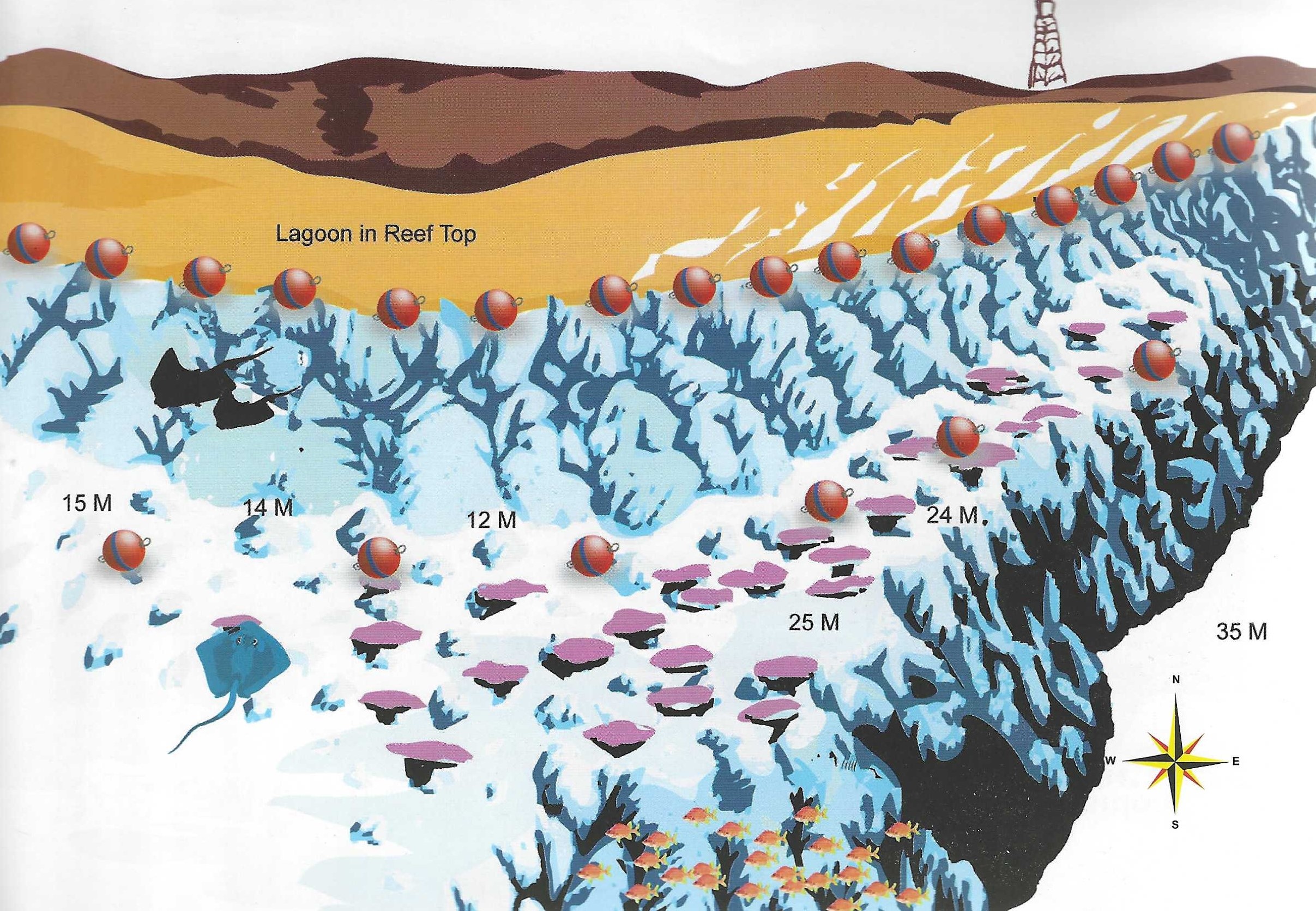
- Location – 90 minutes to 2 hours north of Hurghada depending on the weather and where you leave from. It is a vast horseshoe shaped reef with its open side facing south. At the centre of the horseshoe is a shallow lagoon dotted with ergs (hence the name). It is dived in a number of places: on the north point, on the east wall, or on the south west point (illustrated) known as Gota Shaab el Erg. The latter is the most popular. A shallow channel separates a large erg from the main reef. On the south and west sides is a wide sandy plateau and numerous towers and coral blocks.
- Sea Conditions – It can be rough getting there, but on arrival, you couldn’t find a better anchorage. Current on the Gota is mostly weak.
- Dive Plan – Forget the main reef, there is easily an hour’s good diving on the Gota and its surrounding towers and pinnacles alone. Four very photogenic blocks lie in 16m water to the south (they are cut off from the illustration).
- Marine Life – Most local guides have two things to say about Shaab el Erg – Dolphins and Mantas. Dolphins can be seen frequently all year round in the lagoon, manta hang out on the north point and are seasonal (February, March are the best months). On the plateau surrounding the Gota are scorpionfish, leopard groupers, snowflake morays, blue-spotted rays and painted triggerfish. Underneath the table corals look for whitetips. In the sand you can find coneshells, spireshells and flatfish. On the shallow reef reside unicorns, emperorfish, bream and snapper.
DIVE TYPE
WALL/DROP OFF
LEVEL
ADVANCED
MAX. DEPTHT
14 METER
SHAAB HAMDALLAH
DESCRIPTION
SHAAB HAMDALLAH
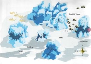
- Location – At the southernmost point of the large shallow plateau surrounding Shaab Shehr lies Shaab Hamdallah. It is a collection of tall ergs that rise up from 18m. They are arranged in roughly the same positions as the dots making up the five on a dice. The central erg is the smallest, but perhaps the most colourful, being richly swathed in soft coral. The southernmost is steeply overhung and sports a lavish growth of gorgonians. The largest erg is the northern one which has a soft coral lined tunnel through its middle, and to the west is a split erg through which you can swim.
- Sea Conditions – This site is a bit like Hal Hal in that it offers zero protection for your boat. This means it can only be dived in really calm conditions. The current can be anything from nonexistent through to highly inconvenient, though it is never too strong to dive in.
- Dive Plan – Basically, circle the ergs in any order you choose. The swim-through, though tempting, should be avoided since even your bubbles can dislodge the soft corals growing within. Take care, also, as you go through the canyon of the split erg. There is a large and pristine table coral, so watch your buoyancy. There are several more ergs to the south but generally these five are more than enough for a single dive.
- Marine Life – About one hundred blue cheek butterfly fish live between the northern erg and the gorgonia erg whilst the tunnel is home to several of the small white greasy grouper. On the towers themselves are numerous scorpionfish and false stonefish and on the sand between them is one of the few places you can encounter spiny devilfish.
DIVE TYPE
PINNACLE, NEEDLE, SEAMOUNT
LEVEL
BEGINNER
ADVANCED
EXPERT
MAX. DEPTHT
20 METER
SHAAB ESHTA
DESCRIPTION
SHAAB ESHTA
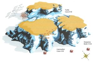
- Location – Shaab Eshta is 45 minutes to one hour from Hurghada. It is basically two ergs, a small one to the north, a large one to the south and it is shaped a bit like a clover leaf. Ishta is Arabic for “cream” but it’s also a term of phrase equivalent to “cool” in English. The depth ranges from 9 to 12m and it is surrounded by areas of turtle grass.
- Sea Conditions – The sea is calm more often than not and the current is always light except in the channel between the two ergs.
- Dive Plan – It’s a small dive site and you can circle it twice in a figure 8 at different depths. Head out into the turtle grass beds, where you’ll find a wide variety of unfamiliar fish.
- Marine Life – In the turtle grass look for packs of lionfish, bluelined emperors, southern stingrays, turtles and sea horses. In the gap between the ergs, there is a school of goatfish plus sweetlips, snappers and on the rubble slope, stonefish, humpback scorpionfish and crocodilefish. There is also a small cave which at night shelters a turtle. A small gully on the southern erg houses a school of hatchetfish and finally, look out for a large malabar grouper which patrols the area.
DIVE TYPE
WALL/DROP OFF
LEVEL
BEGINNER
MAX. DEPTHT
METER
SHAAB PETRA
DESCRIPTION
SHAAB PETRA
- Location – 45 minutes southeast from Hurghada two ergs come to the surface from an 8m sandy seabed. They are about 50m apart on an east-west axis. To the east of these ergs is a small coral block (the best part of the dive).
- Sea Conditions – Usually calm with a mild current from the northeast or northwest.
- Dive Plan – Spend your time on the eastern erg and its outlying block. The block is teeming with life and will impress even the most jaded diver.
- Marine Life – The coral block has a few large holes containing glassfish and hatchetfish which spill out onto the surrounding reef. Above swarm silversides and tiny goatfish. Orangespot and bluefin trevallies hunt amongst them. The main ergs are not as interesting but have various large holes, home to squirrelfish, soldierfish, cardinal fish, glasseyes and hatchetfish.
DIVE TYPE
WALL/DROP OFF
LEVEL
BEGINNER
MAX. DEPTHT
15 METER
SHAAB SABINA
DESCRIPTION
SHAAB SABRINA
- Location – This reef, also known as Fufuleya, lies 60-90 minutes from Hurghada. It is marked by a pointed tongue of reef poking out from the east side of Giftun Kebir. To the south side of the tongue it is basically dead. To the north though is an attractive hard coral garden that extends northeastwards as a succession of alternating coral ridges and sand patches. There is a beautiful shallow lagoon 150m past the tongue.
- Sea Conditions – Perfectly calm on the surface but you may encounter occasional strong currents during the dive.
- Dive Plan – This is best dived as a drift. Jump in 200-300m past the point and weave your way back to the moorings through the coral garden. If you can locate it then spend some time in the shallow lagoon basking in the sun. Its entrance is at 2-3m.
- Marine Life – Shaab Sabrina is mainly dived for its impressive coral landscape, not for its fish life. Nevertheless, expect to see puffers, turtles, bannerfish, bluecheek butterflyfish, cornettfish, various surgeonfish, broomtail wrasse and bicolour parrotfish. In the lagoon are cornetfish, clams, pencil urchins and yellow chromis in an oasis of staghorn hushes and plate firecoral.
DIVE TYPE
WALL/DROP OFF
LEVEL
MAX. DEPTHT
14 METER
SHAAB SAMMAN
DESCRIPTION
SHAAB SAMMAN
- Location – About 3-4 miles north of Ras Abu Soma is another headland known as Ras Umm Hesiwa. To the northwest of here in the direction of Sharm el Nagar is a little known reef called Shaab Samman. A hard coral ridge runs parallel to the shoreline and is separated from the main reef by a narrow, sandy canyon. At its shallowest point, the canyon is 8m though in either direction it slopes gently to greater depths. The ridge itself has a high point at 2m and, like the canyon, it too tails off at either end into deep water. On the seaward side of the ridge is a broad plateau between 15 and 20m deep.
- Sea Conditions – What keeps this reef special is the weather. Nine days out of ten it is undiveable and this is how it has retained its atmosphere of virginal beauty. The current like the sea can also get fairly lively at times, running from the northwest to southeast.
- Dive Plan – Don’t go in with a plan. This place is so packed with fish you won’t know where to start. There’s no need to go deep, everything is in 15m or shallower.
- Marine Life – Okay, here goes, Shaab Samman has everything and by the ton. Large schools of red snapper, black snapper and Red Sea chub hang out on the west end of the reef. Schools of barracuda, jacks and batfish circulate over the plateau, as do schools of unicornfish. On the shallows of the east end of the ridge are onespot snapper and the biggest school of bream you may ever see. There is a barracuda cleaning station close to the mooring. In the sandy canyon whitetips are often found sleeping and morays and crocodilefish are plentiful. Being so close to the open sea there is always a chance of big pelagics, eagle ray and schools of orangespot jacks.
DIVE TYPE
WALL/DROP OFF
LEVEL
BEGINNER
MAX. DEPTHT
25 METER
SHAAB SHEHR
DESCRIPTION
SHAAB SHEHR
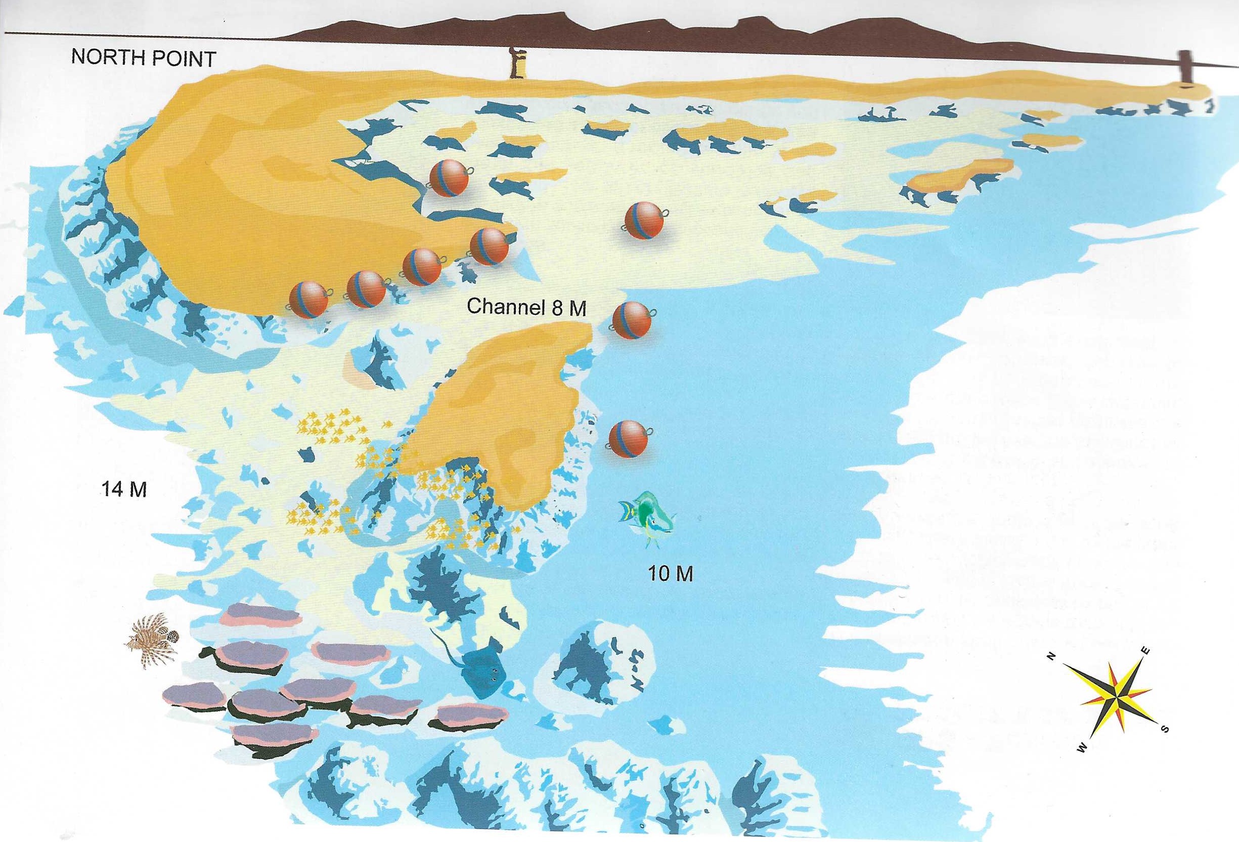
- Location – Around 70 Minutes from Safaga. On the admiralty charts it’s known as Hyndeman reef (that name is no! used locally) and the name Shaab Shehr is attributed to Abu Kafan. These are fishermen’s names and are older than the admiralty itself. So forget the charts. The reef is a horseshoe shape over 1km long. It is an excellent anchorage with three excellent dive sites close at hand and 6 others within easy reach by zodiac. The illustration shows the east end of Shaab Shehr where three ergs form a channel with the main reef. Outside is a vast brain coral garden with a lunar atmosphere and in the three ergs arc some superb caves and grottoes.
- Sea Conditions – The exposed north of the reef can get rough, but the south is always well protected. It’s almost a lagoon. The current can also run strong along this north side, splitting in the middle and running east and west. The west side is on the deep South Safaga Channel and tends to run strongest although the shallow channel between the three ergs and the east end of the reef can also get a little lively.
- Dive Plan – You have three choices: drift dive the north plateau and drop-off dive the west side from the moorings, or dive the east side and the brain coral garden. Leave the moorings and head out through the channel at 12m. Cross the brain coral garden on your way to The northern reef – the drop-off (30m) is too far away to be worth visiting but the plateau is very photogenic with schools of bannerfish, redfangs and occasional jacks. Turn back with enough air to spend time in the grottoes and swim-throughs of the ergs. The middle one is best.
- Marine Life – This site is dived for its unique lunar landscape, not for its fish life. Nevertheless, you will still see all species of triggerfish – picasso, redfang, orange striped, litans and yellowmargin triggerfish. Bicolour parrotfish, scribbled filefish and slingjaw wrasse are also abundant. On the northern plateau and drop-off bream, bigeye emperors, jacks, black and red snappers are common. Spanish mackerel, tuna schools and barracuda schools are also seen.
DIVE TYPE
WALL/DROP OFF
LEVEL
BEGINNER
ADVANCED
MAX. DEPTHT
30 METER
SHABRUHR UMM GAMAAR
DESCRIPTION
SHAABRUHR UMM GAMAR
- Location – Like Umm Gamar, less than one mile to the north, Shaabruhr is a thin slice of reef lying on a north south axis. Unlike Umm Gamar it has no island or beacons to mark its surface. For this reason it has claimed three ships, the wrecks of which now lie beneath the surface. On the southernmost point is the remains of an old Egyptian vessel that used to supply the army on Shadwan Island. There is also a dive safari boat at great depth and from more recently, the famous Colona IV also at great depth. All around the island is a plateau between 15 and 30m. It is narrow on the south and east sides and broad and sandy to the west. The north end has a ridge that extends at 25-30m for several hundred metres. Shaabruhr simply means small reef.
- Sea Conditions – Shaabruhr offers less shelter than Umm Gamar but it’s usually okay to moor up. Current can run quite strong down the east side, though the mooring area is usually calm.
- Dive Plan – There are two good dives here. Either drift the east wall,or dive the south plateau, taking in the wreck and drop-off beyond it. Return along the shallow reef where there are numerous small caves and overhangs. Finish the dive shallow on the mushroom shaped erg.
- Marine Life – On the plateau, you may cross paths with morays, napoleons, large groupers and bluespotted rays. On the drop-off are whitetips, jackfish and some big tuna. This is the best place in Hurghada to look for grey reefs (especially in the afternoon).
DIVE TYPE
WALL/DROP OFF
LEVEL
BEGINNER
ADVANCED
MAX. DEPTHT
24 METER
SMALL GIFTUN
DESCRIPTION
SMALL GIFTUN
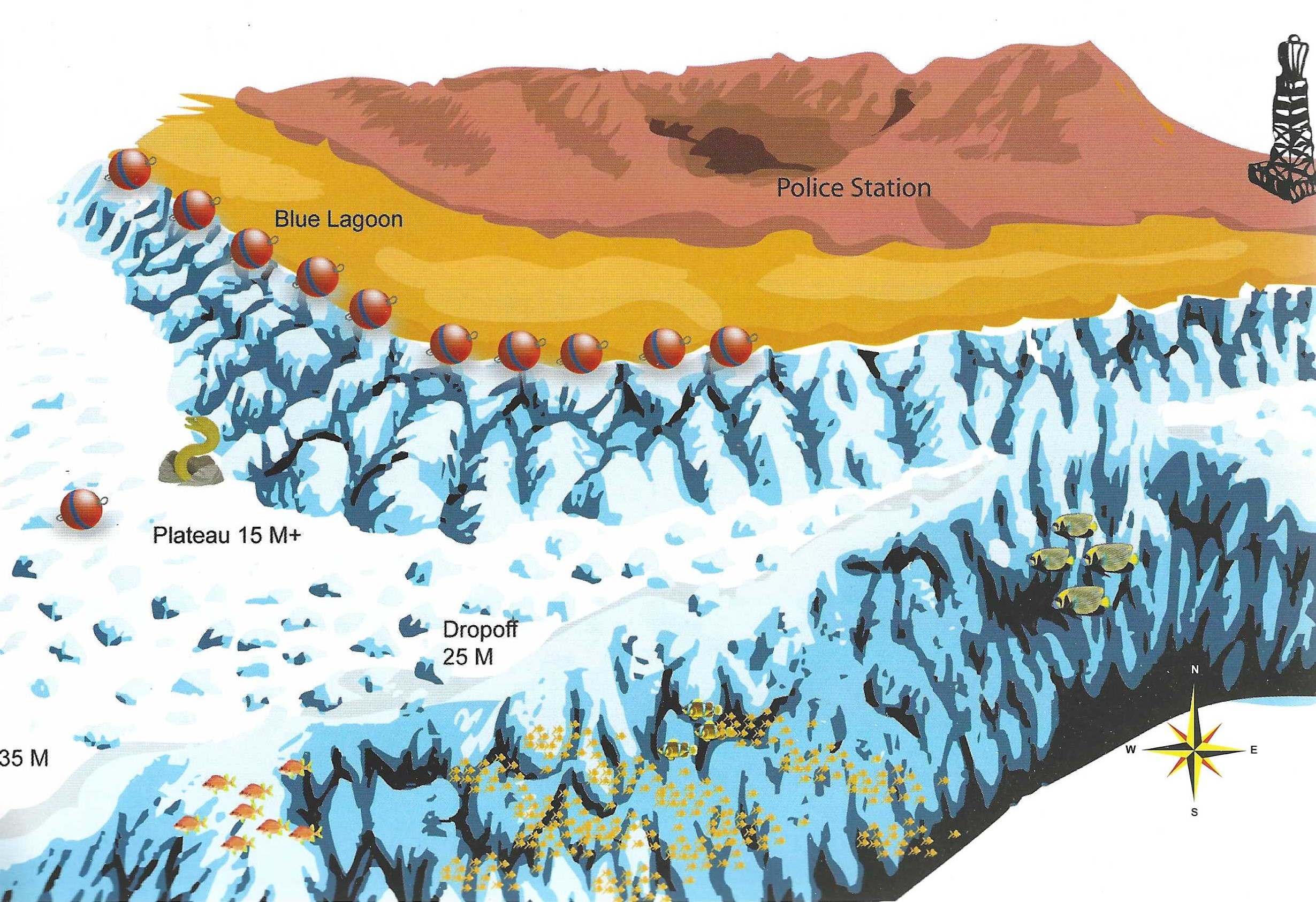
- Location – Around 80 minutes from central Hurghada, opposite the small Giftun police station there is one dive that invokes more enthusiasm than any other. It is a drift along agorgonian clad wall chat merges with an extensive plateau and drop-off . The plateau lies between 15 and 25m and the wall apparently has no bottom.
- Sea Conditions – Sometimes choppy near the drop-in point but your boat will wait in the calm water of the moorings, close to the blue lagoon. Current is always from the north, but is unpredictable – sometimes mild, sometimes howling.
- Dive Plan – Where you drop in depends on how good you are on air and how deep you intend to go. Opposite the two beaches is a safe bet. Opposite the tower is also possible. Put your right shoulder to the reef and head south. There are caves at 35m and a tunnel leading from 40 co 45 (out of bounds for most dive centres). Where the plateau starts, you can continue following the drop-off but take care not to go too far or you’ll lose the main reef.
- Marine Life – On the plateau, napoleons and morays are guaranteed. This is because they have been fed in the past. Feeding marine life disrupts the natural ecosystem, please don’t do it. There are also many bluespotted rays, painted triggerfish and crocodilefish. On the drop-off are turtles, jackfish and early in the morning, a very good chance of sharks. In September, beware of titan triggerfish.
DIVE TYPE
WALL/DROP OFF
LEVEL
BEGINNER
MAX. DEPTHT
25 METER
SOUTH ABU RAMADA
DESCRIPTION
SOUTH ABU RAMADA
- Location – 60-90 minutes away. On the southern end of Abu Ramada a small islet and 3 large boulders are separated from the main island. The dive site is on the reef south of here. To the east of the mooring points a sloping wall tumbles away to 35m. A long swim away is a bubble-like grotto with several entry points. It is filled with many varieties of soft coral, sweepers, cardinalfish and soldierfish. To the southwest are numerous shallow pinnacles with abundant fish life. The seabed here is a bare, lunar looking concretion of compacted sand.
- Sea Conditions – Always calm except on a southerly wind (rare). Current is mild (if at all) at the east and west corners.
- Dive Plan – Head west from the moorings at about 25m. The deepest of the pinnacles is at about this depth. It has a split running through the middle that looks like the mouth of a clam shell. It provides sanctuary to soldierfish, glasseyes, hatchetfish and also sweetlips. From here, head onto a shallower shelf behind, this is where the remainder of the pinnacles are. Spend your time here, returning shallow along the main reef.
- Marine Life – Numerous free swimming morays, bannerfish, napoleons, emperorfish, sweeclips, unicornfish, goatfish and squid.
DIVE TYPE
WALL/DROP OFF
LEVEL
BEGINNER
MAX. DEPTHT
METER
TOBIA ARBAA
DESCRIPTION
TOBIA ARBAA
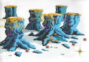
- Location – Just inside the headland of Ras Abu Soma is a closely packed clump of erg known as Tobia Arbaa, Arbaa means four but there are actually seven of them, hence their other name “The Seven Pinnacles”. As ergs go, they are unusually tall and narrow and they stand on a sandy seabed at 12m like a forest of sawed-off tree trunks.
- Sea Conditions – In the lee of Ras Abu Soma, this site is guaranteed wave and current free.
- Dive Plan – The illustration is more an impression than an exact statement of position but don’t worry, each erg is within sight of the next and it’s easy to find your way around.
- Marine Life – This place was designed for photographers. Clouds of anthias and basslets cover soft coral clad overhangs to give that classic Red Sea image. There are lionfish by the dozen and also pufferfish, napoleons, barracuda and occasionally even a large potato cod. On the sand lurk spiny devilfish.
DIVE TYPE
WALL/DROP OFF
NIGHT DIVE
LEVEL
BEGINNER
ADVANCED
MAX. DEPTHT
15 METER
TOBIA HAMRA
DESCRIPTION
TOBIA HAMRA
- Location – About 30 minutes outside Safaga is a long reef topped at the south end by a sandy island (Tobia Island). At the north end is a long low rocky island and to the east of this is the dive site. The reef slopes gently to 30m as a series of hard coral ridges and sandy roads.
- Sea Conditions – It is protected in the lee of Ras Abu Soma so there are no waves and very little current but, like anywhere, it can get windy.
- Dive Plan – Get yourself lost amongst the labyrinth of sandy roads and gullies and then try to find your way back. The rule here is the shallower the better. The best stuff is above 15m. The north end has better topography and makes the nicer diving.
- Marine Life – This place is dived more for the scenery than for the fish life. However, you can find schools of bream, bigeye emperors and several other species of emperor. Stonefish and scorpionfish lie on top of the coral blocks and in the deep water 30m + you may chance upon a leopard shark. Broomtail wrasse are prolific and are presumably responsible for the urchin fragments which scatter the sand.
DIVE TYPE
SNORKELING
LEVEL
BEGINNER
ADVANCED
EXPERT
MAX. DEPTHT
18 METER
TOBIA AL KABEIR
DESCRIPTION
TOBIA AL KEBEIR
- Location – Ten minutes southeast of Tobia Island and only 30 minutes from Safaga is one large oblong reef with a chain of three ergs stretching southwards. The west side stands in 6-7m water and is naturally dead, like a lagoon. The east side shelves to 15m and catches enough current to be quite colourful.
- Sea Conditions – The mooring area is well protected from the sea. Current is usually mild from the north.
- Dive Plan – Head out through the obvious channel between the ergs and main reef and head north. Turn back with enough air to investigate the chain of ergs to the south, staying on the outside where there is more life.
- Marine Life – Many species of triggerfish are represented here redlined, painted, half moon, titan and picasso fish. Abudjubbe wrasse, slingjaw wrasse and especially broomtail wrasse abound. This gaudily painted fish is the drag-queen of the coral reef. Its gay carnival of colour adds a lively note to even the dullest dive. In summer this site is sometimes visited by bottle nosed dolphins.
DIVE TYPE
WALL/DROP OFF?
NIGHT DIVE
LEVEL
BEGINNER
ADVANCED
MAX. DEPTHT
16 METER
TOBIA AL SAGHAIRA
DESCRIPTION
TOBIA AL SAGHAIRA
- Location – Thirty minutes cast of Safaga three chains of connected ergs come together to form an inverted Y-shape. They stand in 12-15m water on a white sand seabed and pose a navigational nightmarre for the average diver arme with anything less than a submersible GPS. To the north they join with Tobia Kebir.
- Sea Conditions – Usually okay, although the moorings are not so well protected from waves. Current can get strong especially down the east side.
- Dive Plan – The two southernmost erg chains are the best. The eastern one has a narrow canyon at llm and a tunnel at 9m. Look in but don’t go through. It is lined with beautiful white soft corals which can be knocked off by a careless fin or even by your bubbles. The western erg chain has three rubble filled channels which can be crossed shallow (4-6m). At its north end are 4 imposing mushroom shaped towers.
- Marine Life – Bluespotted rays, triggerfish and schools of surgeonfish, bream and bigeyed emperors. On the east side between the tunnel and canyon, is a large school of bannerfish.
DIVE TYPE
WALL/DROP OFF
LEVEL
BEGINNER
MAX. DEPTHT
15 METER
UMM GAMAAR
DESCRIPTION
UMM GAMAAR
- Location – Umm Gamaar is a long thin streak of reef lying on a north south axis, 90 minutes north of Hurghada. To the north and south are small plateaus in the 20m range. On the cast side a vertical wall plunges into the silent blue beneath. It is most commonly dived on the south plateau (near the moorings) and the cast wall. Umm Gamaar means “Mother of the Moon”, possibly a reference to the crescent shaped wedge of island atop the reef.
- Sea Conditions – Again, choppy on the way over, but protected once you get there. Current is not usually a problem. If there is any, you’ll find it on the southeast corner.
- Dive Plan – Where the east edge of the plateau merges with the wall there are three coral towers. The first is hollow and round and filled with glassfish, as is the second which is taller and more sculpted in shape. The third has a large sandy cave at 27m. All three are richly swathed in purple soft corals and a swirling mist of glassfish. What more could you need.
- Marine Life – On the plateau you are sure to encounter napoleons, morays, cornetfish, batfish and schools of bannerfish. Whitetips cruise by from time to time. In February/March mantas occasionally make an appearance and in September titan triggerfish are guarding their nests. On the coral towers the usual predators of glassfish can be located – stonefish, scorpionfish, humpback scorpions and lionfish.
DIVE TYPE
WALL/DROP OFF
DRIFT DIVING
CAVERN/CAVESNORKELING
PINNACLE, NEEDLE, SEAMOUNT
LEVEL
BEGINNER
ADVANCED
MAX. DEPTHT
23 METER
